Saturday, October 6, 2018

Royal Arch Cave - Springfield, NH


I have a backlog of nearly 50 places we've been to that someday I hope to write about, and we are constantly adding to that list. Newer adventures get added to the bottom while I chip away at the older ones, but every now and then a place comes along that is so good it jumps right to the top. This is the case with the Royal Arch Cave in Springfield, NH.


I'd first learned of this cave in an issue of the NE Caver magazine, but because it was listed as an "overhang" cave I didn't have it high on my priority list. An overhang cave to me sounded like I'd be standing under a doorway awning, and I like my caves to be deep and dark and with the potential of being eaten by wild animals. So there is sat at the bottom of my to-do list, until recently I received an email from a reader asking if I'd ever been to it. He convinced me it was something I'd enjoy, so on a recent afternoon a group of us went to find out for ourselves.

We began our hike from a dirt lot along the side of route 114 where a trail known as the SRKG crosses, but we'd barely gotten the blood going in our legs before I was bringing the group to a halt to check out the top of this car we found. Besides being a crumpled mess, I still don't know if the bottom half was buried or just missing.


Not long after this our hike came to a stop again, but this time so we could scratch our heads at a sign telling us that the trail was closed.


Turns out they are logging this section of woods - a legitimate enough reason to close a trail - but because this was a Sunday we made it through the empty worksite without any trouble.


Our next stop was at a ledge called the North Overall, a little more than halfway into our hike.


Not knowing the cave's actual location, we reached Royal Arch Hill with the expectation we'd be doing some searching. Fortunately, the good folks who maintain the SRKG had this sign waiting for us.


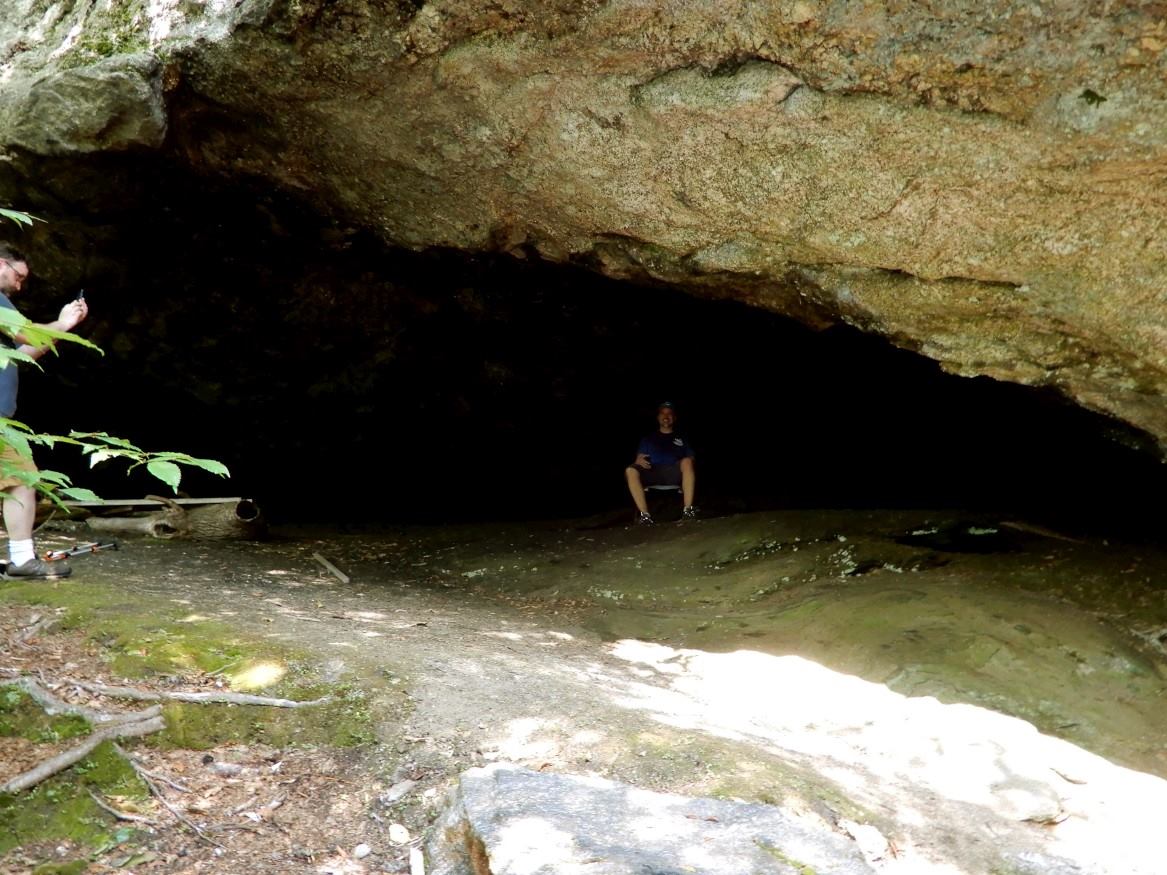
But here's the trick - these directions bring you to the ledge the cave exist in, but not the cave's front door. Locate a faint path to the right of the ledge and scamper down, then soon you'll be greeted with this sight.


Not only was finding the cave a relief, but so was its cool air on this unseasonably warm day.


This is a large, impressive cave, which I'm convinced would be a tourist attraction if it weren't hidden three miles deep in the woods. Some people are making regular visits to it, though. A fire pit, a makeshift bench, and one of those plastic chairs you'd find in a classroom were all scattered within.


We'd been told to look in the rear of the cave for the words Royal Arch, and we easily found them carved into the wall. They were big red letters that seemed obvious to me someone took their time creating. Curious of who that was, that week I exchanged emails with the Springfield Historical Society to learn more about it, but although they are well aware of the cave and of the carving, there are no historical records of either who wrote it or how long it's been there.


My wife and I do a fair amount of hiking, but we consider ourselves explorers much more than we do hikers. This day was perfectly fitting of that description. As part of a larger trail system, this was an enjoyable area for anyone just looking to hike, but if you also have that itch to break off trail and do some exploring, the Royal Arch Cave is one of the best secret places New Hampshire has to offer.

Thank you Arnold for the suggestion!


Saturday, September 22, 2018

Ruggles Mine


It is no exaggeration to say that Ruggles Mine of Grafton New Hampshire was once a world class operation. It began in 1805 when entrepreneur Sam Ruggles began scooping up various lots of property that he'd discovered were rich with mica, and by 1810 he was extracting mica from the site at full force.


Fearing competition, Ruggles kept its location secret by employing only family to work in the mine, and by selling the mica out of a warehouse in Boston. In 1834 the mine was passed down to his son George, then over the years changed hands several times before in 1932 it was purchased by the Bon Ami Company. They mined feldspar from the pit, a multi-use mineral that at the time was used for enamel surfaces, glass cleaner, and false teeth.


Bon Ami owned it through 1959, but there ended the glory years for Ruggles Mine. American miners could no longer compete with cheap labor overseas, and most companies had turned to importing their minerals from countries like Brazil and India. Four years later Ruggles was turned into a tourist attraction, where for a small fee the public could chip away at the walls of the mine and bring home any of the cool rocks they found.


Our first trip to Ruggles was in the early 1990's. At the time I wouldn't have known a chunk of mica from a chunk of gravel, but I'd seen pictures of the place in brochures, and I dragged my wife there simply so I could wander through all its giant caverns.


That was a great trip, but although we were free to explore the open pit and chambers, the tunnels and upper levels were strictly off limits.


It wouldn't be until 25 years later that I would finally have the chance to see all the secret places Ruggles kept hidden from the public.


There were enough twists and turns in this labyrinth to actually get myself turned around a couple of times. At one point I found myself thinking I'd reached the exit, but instead was looking out a hole halfway up the cavern wall.


I spent some time fussing with my camera's timer trying to recreate a picture from 25 years ago, but it didn't work out. The sun was in no mood to cooperate and I couldn't get rid of the glare. Plus, I realized that night that I had been sitting in the wrong spot the entire time. Also, I no longer have any hair.


In 2016 Geraldine Searles, whose husband purchased the property many decades ago for $20,000, closed Ruggles Mine and put it up for sale at a $2 million pricetag. Although there has been interest, it hasn't sold yet and there's no guarantee it will open back up to the public if it does. But there is hope. A petition has been circulating online to turn this area into a state park, and New Hampshire is in the early stages of seriously considering doing this. My fingers are crossed, for until that time this historical place, and one of our states's most magnificent areas, will remain hidden from the public's view.


Links:
https://web.archive.org/web/20170420055210/http://www.rugglesmine.com:80/
http://www.nhpr.org/post/nh-exploring-idea-making-ruggles-mine-state-park#stream/0

Saturday, September 8, 2018

Remnants Of The Elbow Pond Community


If you were to visit Elbow Pond in Woodstock NH prior to the 1970's, you'd have found dozens of cottages surrounding this small body of water. Visit this same area today and you won't find a single one of those cottages remaining, but you will find plenty of evidence that there once was a small community who lived here.


There are pictures online - much better than any that I'm about to show you - which document these scattered remains, and I'd gone up the previous summer in search of them. I biked from a parking area on Elbow Pond Road until reaching the water, and although I enjoyed a couple of hours roaming through the woods, as for finding any remnants? I returned home that afternoon with my tail between my legs.

So I did what I do best when one of these searches gets me stumped, I asked for help. Joined by our hiking partner John, who by his own account had been to Elbow Pond oh around six or seven times, a group of us broke out the snowshoes in the winter of 2018. Going in the snow was not an error in judgement, it turns out that many of the remnants are on the far side of the pond, and rather than trying to reach them through marsh and swamp during warmer weather, we'd instead be enjoying a leisurely stroll across the ice.


If there was one single thing I wanted to find on this trip, it was this truck. Half buried in the ground and with some crazy homemade winch mounted to the front, its picture is what had originally put Elbow Pond on my map of places to explore.


We also found the second vehicle on my hit list, this smiling relic.


Although located in somewhat of a remote location, we did come across a few other people that afternoon: some ice fishermen, a few cross country skiers, and by a stroke of luck that made me want to play the lottery that night, an elderly gentleman who once actually lived here and was happy to stop and chat. He recalled cottages existing as far back as his memory took him, which was the 1930's, and he himself owned one up until the 60's. He was quick to point out that he only owned the cottage, not the land, as was the case with all of them. The land was owned by a logging company who, in an indication of how the world used to be a very different place, freely let people build their cottages and live along the pond.
Does Elbow Pond still have a resident?


This arrangement worked fine for everyone until the 1970's, at which point the land became more valuable to the White Mountain National Forest than it was to the logging company. The government purchased the property, and if there's one thing they were not about to tolerate it was a bunch of squatters living freely on their land. Cottage owners were given just 30 days to leave Elbow Pond, and according to the story this gentleman told us, many did not go peacefully. The more irate among them burned their cottages to the ground, and anything deemed to much trouble to carry was simply left. Many of those belongings remain today, with stoves being the most plentiful of all. I think we stopped counting them when we got into the double digits.


We marveled at the thought of so many cottages being set ablaze, and spoken like a man who had the good fortune of selling his own cottage just prior to it becoming worthless, the gentleman finished his story by saying that yeah, people were mad as heck at the time, but in the end it was a great thing because look at what a beautiful place we all have to enjoy now.
Tina getting shorter


Though I imagine there are former residents with a very different view of things, I personally couldn't have agreed with him more.


Links:
https://www.scenicnh.com/blog/2015/09/abandoned-elbow-pond-community/

Place Names of the White Mountains - By Robert Hixson Julyan, Mary Julyan

Saturday, August 25, 2018

Urbex NH - Kimball Castle


Perched in the hills of Gilford New Hampshire, overlooking Lake Winnipesaukee as it waits for some ambitious person to restore it to its former glory, stand the crumbling remains of one of our state's most neglected treasures - Kimball Castle.


When you're one of the super rich in society but also have an imaginative side, you do things in life like building a castle to use as a summer residence. Benjamin Ames Kimball was one of those people, and that's just what he did in 1899, bringing in material from as far away as Germany and hiring 100 Italian stone masons to construct this residence. As president of the Concord & Montreal Railroad, Kimball lived a life of first class, not only affording the $50,000 it cost to build this castle (remember, that was in 1899 money), but also building a railroad station at the bottom of the hill so he could commute to work in his own private rail car.


Following Kimball's death in 1919, the castle remained in the family until 1960 when Charlotte Kimball, his daughter-in-law and the last family heir, passed away. Charlotte was determined to do good with the family fortune, so she donated the castle as well as several hundred thousand dollars to a charitable trust, with the specific instructions that the property never be used for commercial purposes. No good deed goes unpunished, however, and due to this limitation the property has sat abandoned ever since.


Although the outside is fashioned after a castle that Kimball is said to have seen along the Rhine River in Germany, if you were standing on the inside and didn't know any better, you just might think you were standing inside a very nice, but very ordinary, mansion. There is very little medieval about the interior of Kimball Castle - no great halls, no suits of armor, and other than the day I was exploring, no court jesters.


And though it's still standing, Kimball Castle today is in just the type of condition you'd expect from a building that's been neglected for so many decades - rotted insides being held up by crumbling outsides. Great care had to be taken when climbing this particular set of stairs so that we didn't drop back down to where we'd started from. It's because I explore places like this that I have both disability and accident insurance through our Aflac plan at work.


We made it to the top floor, but the rooms up there were in no better shape then the stairs that led to them.


It wouldn't be urban exploring if we didn't come across beer cans and graffiti at some point, and Kimball Castle was no exception. But I've seen worse, though. And besides, at least one person took a break from the anatomy drawings long enough to actually paint something descent. And local.


These pictures were taken in 2016, so what has been happening to the castle since then? Judging by the lack of updates on their website, I'm pretty sure you're looking at it. But although the place continues to rot, there are still some people trying to do something great with it.


In an effort to tempt a buyer, Charlotte's restriction on commercializing the property has been lifted, and approval has been given to turn the place into a hotel and restaurant. Also, much of the surrounding land has been sold to create a very nice hiking preserve.


But the castle itself will need a whole lot more than a facelift to bring it back to habitable, which in turn is going to take a pretty unique person. You know, one of those super rich and imaginative types. They're out there though, and they did it with the Wentworth By The Sea, so here's hoping one of them comes along someday, restoring its magnificence and allowing Kimball Castle to open its doors to visitors once again.


Links:
Kimball Castle Official Website

Saturday, July 7, 2018

The Valencia Mineshaft


Located in the mountains of Grafton County New Hampshire, the Valencia Mica Mine was in operation for just 12 years before a tunnel collapse forced its closure. Fortunately, the collapse happened at noontime while men were at lunch, so although many of their tools were lost in the rubble, none of their lives were. This was in 1892, and the mine didn't reopen until 60 years later when another company decided to give it a go. Today what remains of the site include some old railway tracks, a large but flooded cavern, one tunnel, and a pair of very un-excitable porcupines.
Photo Credit: John Egolf


This hike was one of the more enjoyable we've made while hunting these old mineshafts. Often these expeditions consist of several hours of bushwhacking with periodic breaks to yank out thorns, but here the terrain consisted of mostly an old logging road, and round trip came to just under two miles. Partly why it was so short was due to the sharp eye of my hiking partner John, who spotted the hint of a trail in the opposite direction I was leading us. And although we'd started this search not knowing what, if anything, would be left of the operations, we realized today was going to be a good day when we first came across these old mining rails.
Mining Rails


Just beyond these rails were the first signs of the mineshaft itself; this small opening. An even smaller passage continued to the other side where sunlight poked through, but although I could have fit I decided it was too early in the day to go getting myself all muddy. If I wasn't able to see what was on the other side by climbing over the hill, though, I planned on coming back here to crawl through. I'm okay with driving home filthy, but I'm not okay with driving home wondering whether or not I missed anything.
Photo Credit: John Egolf


It wasn't until after we'd thoroughly explored the area that the mine's collapse was evident to me. We found 3 separate openings that when you connected the dots ran in a straight line, and I could envision that the entire thing was once one long tunnel. Sections of that tunnel remained, and by crawling down the collapsed areas you could explore them. The largest of these areas looked promising from up top, but once I'd lowered myself down I found it was completely flooded. I made a show of poking around with a stick to see how deep the water was, but we've all smelled stagnant shaft-water before, and we all knew I had no intention of going in it. At least not on purpose.
Photo Credit: John Egolf


Dead ended here, we backtracked to the beginning of the site and over the hill, and that's where all the action turned out to be. Spotting a crevice, I scrambled down and was excited to find the kind of mineshaft we're always hoping to find on these explorations, one that goes farther into the earth than the eye can see.
Photo Credit: John Egolf


Maybe it was due to the collapse, or maybe it was the haphazard way it was dug, but parts of this mineshaft resembled a natural formation rather than something man-made.
Photo Credit: John Egolf


But telltale signs gave it away, such as the horizontal support beam you can see off in the distance.
Support Beam In Distance


We continued into the tunnel until, about mid-way through as we came up over a bend, I looked down and suddenly found myself eye to eye with a porcupine. He stood not even five feet away from me. After regaining my composure (did I yelp like a coward? Only John knows for sure, and he's been sworn to secrecy) we followed him to the end where we found his buddy, then the two of them calmly checked us out and even held still for a couple of pictures. If I were armed with a thousand needles I'd probably take much of life in stride myself. We eventually backtracked out of the tunnel to leave the animals in peace.
Photo Credit: John Egolf


Someday I won't have any new mineshafts to search out in New Hampshire. There's going to come a time when the very next one I bushwhack up the side of a mountain after will be my last. But that's not going to happen for quite a long while. Many more of these underground treasures exist than I ever would have thought possible growing up here in the Granite State, my list of suspect locations is still long, and I have only so much time in my schedule that I can go out searching for them. All of this makes for a very good problem to have, kind of like having too many TV shows you want to bingewatch but not enough hours in the day. I don't know where my search will take me next, but until that very last one is crossed off my list, you can bet that I'll be out there looking.
Photo Credit: John Egolf


Saturday, June 23, 2018

Town Pounds of New Hampshire


I can be as guilty as anyone when it comes to cruising through life with my blinders on. It's so easy to get caught up with things like work, the house, and family commitments to where we're oblivious of all the curious and interesting things around us, and that we just need to slow down every once in a while to remind ourselves what a pretty cool place our world actually is.

This was the case as we were driving through the town of Chester one afternoon. Enjoying a day of just seeing what we could find, my wife spotted a curious stone structure along the side of road that somewhat looked like an old house foundation, but stood too high. I've turned the car around for a whole lot less during our drives, so back we went where we found something I'd only read about until that point - a town pound.

It's hard to imagine in today's society of McMansions and Super Walmarts, but go back a few hundred years and nearly all of New England was farmland. Cows, sheep, goats, and many other animals were part of everyday life for our ancestors, a life that included problems as foreign to us as my wife's flatiron being on the fritz would be as foreign to them. And one particularly problem people dealt with in those days? Sometimes your animals wandered away.

The solution to this was simple enough, however - designate a place where all the strays could be rounded up and kept, until their owners came along to claim them. With that solution came the creation of the town pound.


I soon learned that there are town pounds throughout much of New Hampshire, which brought me full circle with my point about taking off the blinders. Our neighboring town of Durham has one that's maybe fifteen minutes from our house - which I'm convinced I've driven by at least more than once - and I never knew it was there. But now that we were on the hunt for them it quickly became a destination. This one turned out to be part of someone's yard, and either the homeowner or the town is to be commended for keeping it in such good condition.


As to be expected, many of these pounds date back to the early 1800's or prior. We visited one in Hudson a few weeks ago that has been in existence longer than America has even been a country.


Because they all seem to be found along the sides of roads, not only are town pounds great places to stop at to break up a long drive, but every now and then you'll come across one entirely by accident. This is how I found Gilmantown's last winter, and thank you to the neighbor who unknowingly let me park in his driveway while I scooted across the street to take these pictures.


I know this post is about town pounds of New Hampshire, but I'm including one from outside our state simply because it made me chuckle. Look closely and you'll see that the fun people of Upton Massachusetts have a couple of cows occupying their town pound. I tried to get Tina to pet one of them, but she quickly figured out the ruse.

Exploring doesn't always have to mean hiking miles into the woods in search of some unknown cave or ruins. Sometimes it just means getting into your car and driving to a place you've never been before. There are many town pounds that I didn't include on this list, so the next time you're out for a Sunday drive I encourage you to look one up and go for a walk through it. It's a very easy way to experience, if only for a moment, one small part of how our ancestors lived.