Saturday, December 23, 2017

Boise Rock


After reading our blog, you know we set out pretty often to go on an adventure. But on this rare occasion, we got to get away for an entire weekend. We stayed two nights in the White Mountains and spent one of the days roaming the Kancamagus highway and all the roads leading around I-93 and into the Conways.

We made many stops checking out the scenery, waterfalls and monuments. Some of the sights were pretty amazing but when we stopped at Boise Rock, I got out, saw a rock and hopped back in the car and told Dave, “it’s just a rock, lets keep going.” And we did, we checked out many more places, went to dinner and made our way back to the hotel.


I didn’t put any thought into that rock that night. But for some reason, I woke up early the next morning and I thought about the rock and why on earth was it so special to have a name and a tourist stop for it. So while I let Dave sleep in, I starting researching information.

The story about how the rock got its name was pretty fascinating to me but first I have to point out this is no ordinary rock. This rock was moved into the Franconia Notch region millions of years ago during the ice age. It’s funny how nature seems to predict its future because if you look at how this rock sits, it has quite a ledge beneath it. Fast forward to the early 1800’s and the ledge beneath it quite literally helped save a mans life.

A man by the name of Thomas Boise was traveling on his horse through Franconia Notch when a blizzard struck the area. He chose to take shelter under this rock. As conditions grew worse and temperatures dropped he faced the terrible decision to kill and skin his horse in hopes that the hide wrapped around him would help him survive the night. The next day, after not arriving at his destination, friends set out to find him and found him under the rock wrapped in his horses hide. The hide was so frozen, they had to ax it off of him. Thanks to the sacrifice of his horse for the skin and the shelter of the rock, he survived the harsh winter night.


Clearly, this was a remarkable story of survival and the story became so well known, the rock was given his name. I would like to think the horse deserved some recognition in all this, after all, without knowing it he played a vital role in saving this mans life.

About 2 months later, we drove up this way for a hiking trip and I had Dave pull in so I could check out this rock and take some photos. Of course, had I given it a better look the first time, I would have noticed the plaque outlining the heroic story. I immediately thought about how wimpy I am with even the smallest snow storm. I don’t even like to go out to the store for milk, let alone, make a few steps out of my warm house to clear off the car. We have the luxury of knowing our forecasts but back then, they took their chances in travel during those harsh winter months. I’m not sure I could have ever survived those same conditions and killed my horse but you truly don’t know what you are capable of until you are faced with dying or surviving.

Another lesson learned, never judge a book by its cover. So much for it being “just a rock.”


Saturday, December 16, 2017

Abandoned Gold Mine in Grafton County


It's times like these I feel the most alive. The sun was shining, the breeze was warm but not hot, and I overlooked a beautiful river that would have been right at home on the back of a postcard. I had arrived in the mountains of New Hampshire armed with a single paragraph of directions, and I had an entire day to see what I could do with them. My goal? An abandoned gold mine said to exist somewhere along this river.

As I gathered supplies from my car, an elderly man approached and commented what a beautiful area this was. The only trick would be the twenty-foot, nearly straight down embankment required to reach the water, which if the gentleman before me had climbed would have been nothing short of remarkable. My guess is that he'd been admiring the river from on high. We chatted a bit, then he went off to search for some falls he thought might exist a mile or so downriver. Just two adventurers whose paths had momentarily crossed - a good omen to start my day if ever there was one.

My own adventure had started with finding a road that crossed this river, and from that intersection following the river upstream until finding the mineshaft in the side of a cliff. The road was not given by name, but of all the roads that intersected this river I was confident enough I'd chosen the right one to make the hour and a half drive north. And although my research described the mine as being a hundred yards upriver from the bridge, knowing how these things work I was prepared to travel for several hundred yards to look for it, and in both directions.


I navigated the steep drop to the water and soon began what I'll call the wild goose chase part of my search. After rock-jumping upstream a hundred yards and finding nothing, I thought possibly the tunnel was tucked back a little ways in the woods, so I retraced my steps, climbed the far side embankment and started bushwhacking.

The great thing about wandering aimlessly through the woods is that you never know what you'll stumble across, and today I found this abandoned satellite dish that had long since lost its battle with the brush. For any of you born after 1990, you have no idea how popular this would have made me if our family had owned one of these growing up.


I didn't find anything else of interest, but because the steep embankment had turned into a full-fledged cliff I was forced to continue upriver for several hundred yards before finding a way down to the water, which meant I would now be backtracking downstream. This river is anything but boring at least, and even had I not been hunting for a mineshaft it would have been a worthwhile trip, simply for all the wonderful pools and waterfalls.


And it was along this downstream excursion that I struck my own version of gold, spotting the opening of the gold mine across the river and at the base of a cliff, as promised. Even though the location of it wasn't very accurate, the description was spot on.

My problem now was, back in the shallower water upstream, I had wandered back to my original side of the river, and the mineshaft was on the far side. It was also flanked by a waterfall on one side and a pool on the other, two barriers no normal person would attempt to navigate. Fortunately that's not a category I fall into, and after slowly scaling the top of the falls I made it to the entrance with 50% of my feet still dry.


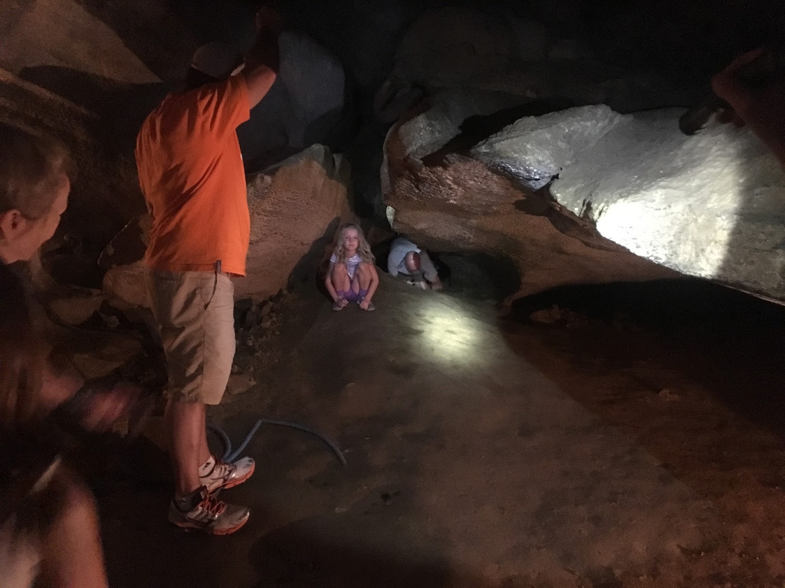
Into the tunnel I went, moving slowly not only so that I didn't miss anything, but so I could stop every few steps and listen, making sure I wasn't waking anyone that wasn't in the mood for company. Before long the entrance curved to the left and I began losing sunlight.


Then I came to something I don't see too much of in our New Hampshire mineshafts; an intersection. Usually these turn out to be quick dead ends where one direction was abandoned in favor of another, but I actually had a decision to make here. I chose left.


As I followed my beam of light I cannot remember if I could still hear the waterfall, but I do remember how cut off I felt from the world, and how creepy it was. With my flashlight off it was the kind of darkness where you could wait for an hour and your eyes still wouldn't have anything to adjust to. If I'd been with friends this would have been a raucous old time, but alone it was a nerve-wracking, jump-at-every-sound kind of journey. There was no turning back now though, so like a kid who stayed out too late and has no choice but to walk home in the dark, I walked through my nervousness and right to the end of this tunnel.


Before backtracking to next see what the right hand turn was all about, I left a little memento in the wall. Someday someone's going to come across one of these coins I'm always leaving behind, and they're going to know I was the one to put it there and will write to tell me they found it. I hope.


Back to the intersection where I took the right this time, and this direction continued maybe twenty feet before winding left and coming to a halt. At this dead end someone had left a little memento of their own, in the form of several empty beer cans. I cursed the hooligans that may all their future beers be flat, and made a mental note to bring a trash bag next time I visited here.


I'd seen everything this mineshaft had to offer now, and roughly speaking the entire thing was shaped like a drunken capital T. Back down the main tunnel I retreated and was soon standing in the warm sunlight once again.


My original research telling me to travel 100 yards upriver came from a geological study done in the 1950's, but oh those tricksters from a half-century ago. Google Maps later confirmed it was 587 feet as the crow flies to reach the mineshaft, and adding the twists and turns of the river the distance was more than double what they'd promised from start to finish. A bit off, but certainly not the hardest place I've ever had to search out.

I used to be a semi-serious runner until learning I was a 40 year old man equipped with an 80 year old's joints, and one of the things I miss most about those days was coming home with a runners high. No matter how miserable a day I was having, by the time I'd finished my evening run it was impossible to be in a bad mood. In many ways exploring has filled that void for me. By combining the physical aspect of hiking with the mental aspect of exploring all these wonderful and sometimes creepy places, I come home with as many feel-good endorphins running through me as I did with my longest runs. Only difference is, instead of basking in that feeling on my back deck with a beer, I'm now basking in it on my drive home, sorting blog notes in my head while trying to out-sing whatever Toby Keith song I have blaring on the radio, often forgetting that other drivers might actually be watching my goofiness.

So, if you're ever driving along our New Hampshire highways and see a bald guy in a black Jeep, singing like a fool and looking a little bit too high on life, you just might be witnessing the origins of a future blog post.


Saturday, December 2, 2017

Blood Mountain Plane Crash Wreckage, Newbury NH


Pilot error is the probable cause of a 1949 single engine plane crash on Blood Mountain in Newbury New Hampshire. As with several other crash sites deep within our mountains, the body was removed but the wreckage remains, and if you ever make the journey to one of these spots, you'll understand why this is a practical decision.

Our expedition to this crash site was a classic case of don't believe everything you read online. Described as a 1.25 mile hike, our directions said to follow a logging road up the mountain until reaching the spot, insinuating that the road led directly to the wreckage and we were facing 2.5 miles round trip over something casual enough my Jeep could crawl up it.

We found the logging road at the base of the mountain, and although it seemed headed in the wrong direction, a helpful bear hunter showed us on his map how it eventually curved uphill and toward the peak. So far so good, and we crossed this small bridge over Blood Brook to begin our journey.


The logging road was an enjoyable hike that got us halfway up the mountain, but then it continued east when my GPS insisted we needed to turn south, and there was not a southern trail to be found. It also insisted that the crash zone was still almost a mile away. No matter how many times I re-positioned it the answer came back the same, so ignoring my wife's reminder that this was supposed to be an easy hike (a reminder punctuated by her patented stink-eye), I announced that it was time to begin our bushwhack.


Into the thicket we went, and although I had to endure more pestering of are we there yet than during the last family drive to North Carolina, thirty minutes later we found the wreckage. So much for the promise of 2.5 miles by dirt road though, by the time we trudged out of the woods later that day we had logged over 5 miles on foot, with a good portion of it bushwhacking.

Accounts I've read say the engine was thrown clear of the plane's carcass on impact, so we split into two directions with me searching for the engine. As a non-mechanic who rarely ventures beyond the yellow-capped items beneath my hood, I still assumed that what I was looking for would look like a big car engine and I'd know the thing when I saw it. Although I didn't find quite what I imagined I would, I came across this spiral armed thing that I believe to at least be part of it.


We also found that, through either the force of the crash or 70 years of growth, some of the plane's debris is actually embedded in surrounding trees.


The fuselage rests downhill from the engine, still possessing enough resemblance to a plane to give me pause, reminding me that this was an area of great tragedy.


I sometimes worry that there's a fine line between visiting a plane crash site to respectfully view the wreckage and learn about the victims, or just being a big old looky-loo. Maybe it's just something each person has to decide for themselves, but I feel comfortable that we fall into the former category and not the latter.


Soon it was time to leave, but rather than being daunted by the treacherous return hike, I attacked the thick brush with raised spirits, happy that our group of friends was able to be out here on this beautiful day, enjoying nature and each others company, and feeling fortunate knowing we'd still have countless more opportunities like this in our future.


Related Links:
http://www.soonipi.com/crash.html - Sunapee Mountain Plane Crash Remembered

Saturday, November 18, 2017

Found! Peter's Oven Cave, Lee NH


Peter’s Oven. This name is given to a natural cave in the side of a steep ledge, a short distance above Lee Hill on the right hand side of the road to Barrington. It is mentioned July 10, 1721 when 100 acres of land, originally granted to Wm. Williams, Sr., in 1662, and laid out to Wm. Roberts in 1663, on the west side of “Whell Rights Pond” were laid out anew to Moses Davis and John Thompson, Jr., beginning at a pitch-pine tree on the west side of the cartway that leads to “Peter’s Oven, so(e) called.”
Landmarks in Ancient Dover, New Hampshire by Mary Pickering Thompson.


That’s a mouthful and a lot of info to digest, but the trick is to cherry-pick only what’s pertinent from the paragraph above. A natural cave exists, on the side of a steep cliff, somewhere north of Lee Hill, with references to it going back nearly 300 years. It doesn’t take any more than that to put me on the hunt for something, and in this case that's a good thing because other than this snippet and a couple mentions under the town of Lee's website, Google shrugged its shoulders at every search attempt I made on Peter's Oven. So with my own little X marks the spot treasure map drawn out, Saturday rolled around and I loaded up my backpack for a hike.

I based this day's search on the story behind the cave's name, of which there are two different legends. One says that back when Native Americans were regularly fighting New England settlers, a battle took place at "Whell Rights Pond" that left a man named Peter wounded, and he was able to stumble to the cave before crawling inside and dying. The second legend tells of a homeless man named Peter who roamed the area and made the cave one of his haunts. Since this second legend didn't offer any clues to the cave's location I chose the pond battle story, and parking about a mile south of the Wheelwright Pond I entered the woods and headed north.

Markers for this being conservation area were on trees throughout my hike, and although I never saw anything telling me I'd exited public land, a couple times I felt like I was creeping onto private property. One such time was when I found this swing for two perched high up in a tree, perfect for those Saturday afternoons when you can't decide if your mood is more adventurous or romantic.


I eventually made my way to the pond, where if Google Maps is to be believed I went for a nice swim, then headed back via a more westerly route. But not only did I not find the cave, I didn't even find any cliffs to give me hope of being in the right area. It was a beautiful day for a hike, but that's all it turned out to be, and after 3 miles of bushwhacking I was forced to go home and call it an unsuccessful yet still enjoyable afternoon.
New Hampshire's unseasonably warm weather continued the following Saturday, and once again I was roaming these woods looking for anything that resembled a cliff. At one point I found myself stepping over a stone wall - nothing unusual in this part of the country - but as I continued walking something in the back of my mind kept kicking that thought around. Stone walls are often used as property lines. Also, the 1721 reference to the cave had been used in the context of defining a property line.

However long it took for you to piece together these clues it took me double, but eventually it clicked and I scrambled back, positive I was finally onto something.


Times like these are full of failures however, and as sure as I'd been that I was getting close, those hopes ended as abruptly as that wall did smack in the middle of nowhere. Day two's search had covered over three miles once again, and with my mind already wandering to what new adventure I should plan the following weekend, I started back.

But with presumed failure sometimes comes a little luck, as happened with my hunt for the Catamount Hill Cave and our group search for the Paddock Mineshaft, for it was during my walk to the car - full of those desperate side-trips to check just one more spot - that I began following a rock outcropping and finally had my breakthrough. For the first time in two weeks I came to an actual cliff, and before I knew it was looking at a suspiciously dark shadow near the top. Upward I climbed.


It was a cave alright, but one I would have to slither into. It wasn't even big enough to enter on my hands and knees. Nevertheless, after two weekends of searching I finally found myself at the opening of Peter's Oven Cave.


So having seen it up close, here is my theory on how it got its name, at least if I'm to choose between the two legends that have carried through the years. The wounded man climbing into this cave to die is more of a stretch to me, because although it wasn't overly hard to scale the cliff, it wasn't overly easy either. And coming down from the top looked even trickier. Would a mortally wounded man be able to make the climb? Possibly, but I'm siding with the legend of Homeless Peter. This was the right sized cubbyhole not only for getting out of the rain, but it was high enough to afford some privacy and protection while sleeping. Plus, it's makes for a great lookout spot, because here's the real kicker - the cave sits in view of this road, just behind a row of trees.


I imagine people traveling this path on foot centuries ago, passing by and never realizing Peter was holed up above, watching them. And on this day I did my best impression of Peter, stretching out my full length into his cave while I snacked on Pringles and secretly watched the cars drive by. 


This led me to my next question - just how visible, or invisible, is this spot from the road? Of all the people who drive it on a daily basis, shouldn't somebody have spotted it by now? It would seem so, but then why couldn't I find a single picture of it online? It was like the Fermi Paradox for caves, so when I returned to my car I decided to do a test.

Driving north, the cave was impossible to see due to the curve of the road and tilt of the cliff. So anyone headed to Barrington was off the hook. Then I drove the road south, and although I was technically able to spot Peter's Oven from this direction, that statement comes with some important asterisks. First is that I knew exactly where to look for it, second is that I couldn't recognize it as a cave but only as the spot where I knew it existed, and third is that I nearly wiped out someone's mailbox in the process. If this were any old road on any old day, I would miss it a hundred times out of a hundred, and I'm speculating that some people might know it's here, but most do not.

If you enjoy large caves that you can stand in and wander around, this one's going to be a real bummer, dude. But if you enjoy local legends, historical mysteries, and beautiful fall afternoons spent hiking through the woods, go ahead and add searching for Peter's Oven to your to-do list.

The enjoyment of this adventure is all in the chase.


Links:
Landmarks In Ancient Dover, New Hampshire, By Mary Pickering Thompson

Saturday, November 4, 2017

Stone Chambers of Littleton Massachusetts


We love our house, but like most people Tina and I can sometimes get caught up with all the things it doesn't have rather than those it does. Being a household of four, having a second bathroom is something we've wished for many a hectic school morning. A metal roof to melt the snow would sure be nicer than climbing up there with a shovel after each storm. And for anyone who has to dig their car out after each nor'easter, you can imagine how much we'd like to have a garage.

But all those ideas got bumped back to second place after I visited a residence in Littleton Massachusetts, and realized the most important thing our house is missing - its own stone chamber.


Although the chamber existed long before the house was built, it sits within their property line and makes these lucky people the private owners of their very own man-made cave. Like those we've talked about in the New Hampshire towns of Danville and Newton, these curious structures are strewn throughout New England and New York, and regardless of whether they're 200 years old like conservative historians believe, or 2,000 years old like the imaginative ones argue, they are always a cool little find.

I don't imagine I'm the first person to ever sneak a peek inside this chamber, and after ducking in for a quick look around I was on my way without a single stone disturbed or even touched.


Descriptions of Littleton speak of a town rich with history, and even a quick ride up and down this street seems to verify this. In many places, abandoned foundations and impressive stone walls stand just inside the treeline, often visible without even a need for me to have gotten off my bike.


If you do choose to enter the woods, and if you know of a particular hiding spot less than a mile from where the chamber stands, a second and lesser-known one is waiting to be discovered. With its tiny opening some have speculated it was once sealed off to keep out destructive kids, but fortunately I am no such thing and down to my hands and knees I went.


Once through the entrance I realized just how deceiving the outside was, as this chamber opened up quite comfortably and allowed for my second photo shoot of the day.


Some adventures are all day affairs spent trudging through miles of woods and bush, others are quick little visits like these that can be worked into another activity, such as an afternoon mountain bike ride through a town you've never visited. In fact, almost anything can end up an adventure if you're on the lookout for it, the trick is to just put yourself in the right position for it to happen. And that position is being out there exploring our towns and all the wonderful things they have to offer.


Saturday, October 21, 2017

Ruins of Camp Wunnegan


Do a little exploring in the woods of Shrewsbury Massachusetts and you might come across the ruins of a former girl scout camp named Camp Wunnegan. History is sparse as for what I've been able to find online - when you're chasing leads from page 9 of Google's search results you know you're desperate - but the info I've scratched together confirms a couple things. First is that the camp was in operation at least until the year 1966, which is the date of an article in the Fitchburg Sentinel newspaper describing an outing at the camp for disadvantaged scouts. Second is that by 1978 the camp was abandoned, at which point the town purchased 30 acres it resided on and added it to an abutting 15 acres it already owned. What happened in-between those years to lead it to such a state of neglect, I've yet to learn.

We made the trip to Camp Wunnegan in the summer of 2017, and right from the start the head-scratching began. Between two residential houses we found the trailhead and a kiosk, an entry path that made it feel like you were walking into the neighbor's backyard, and no parking. It's tough to feel welcomed when you're forced to park around the corner in front of some stranger's house but that's exactly what the map told us to do, and never ones to shy away from doing something uncomfortable, there we parked and in we went.


To come clean, this was a stop-off visit to see the ruins and we didn't have any intention of walking the entire trail system that day, so when we finally spotted our goal that's directly where we headed.


Whatever activities are taking place nowadays in this former girl scout's cabin, you can bet it isn't a cookie sale. Aspiring artists and fire enthusiasts seems to be the main inhabitants lately. Fortunately we were there around noontime of a Wednesday and had free roam of the place, so we were able to work in a few posed pictures. Here is Tina pretending to rub circulation back into her hands after coming inside on that frigid August day.


And here I am resting with a sip of water, something which earned me a roll of the eyes from my wife and a pair of rust-stained shorts.


Speaking of eyes, if you're wondering why I was looking up in that picture I was probably admiring the fact that the roof hasn't collapsed yet.


Being a former scout camp on such a large patch of land I expected there to be more structures, but our search revealed only one other thing. It was a beauty though, this lonely chimney standing a few hundred feet through the woods from the cabin.


Which if you spend a minute searching you may even find a small gift I left behind.


There are things in life that, when added together create a sum that is greater than their individual parts. For me it's a cold beer on a warm summer's day; for my wife it's a chocolate bar dipped in peanut butter; and for both of us it's what we found at this particular patch of woods in Shrewsbury Massachusetts - trails to hike and ruins to explore.


Related Links:
Location of Trailhead
The Path Less Traveled - Worcester Telegram
Exploring an Abandoned Scout Camp (in New Hampshire)

Saturday, September 30, 2017

Hidden Tunnels of Dover (And where to find them)


How many of us go about our lives never noticing all the fascinating and unique things around us, because we're just too caught up with life. We bring the kids to school, work all day, go shopping on the weekends, and all the while there are treasures just waiting to be noticed, if only we'd put down our phones long enough to go look for them. I'm talking about myself as much as anyone here, of my recent fascination with balancing my digital life with my real life, and of my quest to peel back the layers on everything interesting within our communities.

In the past couple years this has brought me to many interesting places, and although there are different degrees to just how secret each one of these tunnels is, I've lived in Dover the past 20 years and it wasn't until the last couple that I knew a single one of them existed. That's off the beaten path enough for me to call each one of them hidden.

How many of them can you name?


Walking Tunnel Below the Spaulding Turnpike
Here's a perfect example of taking the path - or in the case the road - less traveled. On a recent bike ride I was rounding the corner between Knox Marsh and Littleworth Roads, and on a whim took the long way through a side neighborhood I'd never traveled. Where the road dead-ended a paved walkway disappeared into the trees, and that's where I found this tunnel passing underneath the Spaulding Turnpike and into a neighborhood off Silver Street. A nice little walk for local residents, a couple of whom I passed along the way, and since it doesn't take much to excite me, after riding it back and forth I returned that weekend to show my wife and make her pose for this picture.
Click For Location


Blackwater Brook Tunnel
Making a visit to this tunnel is not for the feint of heart, but for anyone not afraid of learning the true meaning of the term bushwhacking, it's definitely worth the visit. Follow the path on a map that the former Newington Branch Railway once traveled to the north, and you'll find where it crossed over the Blackwater Brook. Put on your boots and make the nearly half-mile hike from Pickering Road to this location, and you'll find how the former railway crossed over the Blackwater Brook. This beautiful arched tunnel stands alone in those woods, continuing to do its job even though nobody is watching. My wife had to perform double-duty on this day, first enduring the bushwhack and then posing for my picture once again.
Click For Location


Community Trail Tunnel Below Silver Street
I'm guessing this is the most commonly known of the bunch, but in the words of my thirteen year old son it's also one of the coolest. We've all traveled over Silver Street at one point or another, but how many of you have traveled under it? If you haven't, I highly recommend taking a walk along the downtown portion of Dover's Community Trail, bringing you underneath Silver Street in this long metal tube, which if you're like my wife will make you immediately start singing.
Click For Location


Cow Tunnel Behind Measured Progress?
I will stop to look at anything that catches my eye, and while walking the Watson Road portion of the Dover Community Trail I found myself climbing down the embankment to look at what I assumed was a culvert, one of many that line this section of former railbed. This one was extremely large however, and I called back up to my wife that I'll be darned but it almost looked like a cow tunnel. After taking several moments trying to figure out if I was punking her, she humored me and asked what's a cow tunnel. Back when much of New England was a farming community and railroads often came cutting through, people would sometimes need ways to safely get their livestock from one side of the tracks to the other. Hence what is commonly referred to as a cow tunnel.

Knowing there are several confirmed ones throughout New England, I wrote to the NH Division of Historical Resources with pictures of it, and after exchanging several nice emails with coordinator Peter Michaud he felt that given the size and location there was a pretty good chance this was indeed another one. Of course this is based strictly on information I provided him, he has not seen it for himself, so rather than put him on the hook for any claims I make, I'll leave it with a question mark and a hope; that someone more knowledgeable than I am will someday learn more about it.
Click For Location


Honorable Mention - Stone Railroad Tunnel
As much as I wanted this one to be part of the official list, it's not a place people should be visiting (do as I say, not as I do) so I cannot give its location. But it is in Dover, and it is very picturesque.

That is my list, but I'm certain there are others around town that are as impressive as these, or even more so. For example, haven't we all heard stories about old houses and buildings that have secret tunnels leading underneath roads or to other buildings? I like to think that not all of those stories are urban legends.

I also like to think that one day I'll find myself standing inside one of them.

Saturday, September 23, 2017

Appalachian Caverns & The Virginia Creeper


Our family took a vacation this summer to see my parent's new house in Tennessee, someplace they've lived in for nearly a year but we'd only seen pictures of to that point. My brother and two sisters were there with their families, and it was a wonderful time catching up with my folks, marveling at how big the nieces and nephews are getting, and enjoying a week with no deadlines or spreadsheets. But if you think we didn't sneak in a few adventures while we were down there, then I haven't been doing a very good job of explaining what our family is all about.

Part one of our adventure brought us to the Virginia Creeper, a wildly popular rail-trail through the mountains of western Virginia. The main attraction is to shuttle up the mountain in vans, hop onto rental bikes and enjoy a winding 17 mile ride down the hillside and back into town.


This is meant to be a leisurely ride with various lookout points and sights along the way, and halfway down you can stop at a diner that does more business off the dessert menu than the lunch. I've seen plenty of double-fisting in my days, but never in a situation that didn't involve lots of beer. My dad is a trend setter though, and here was his logical solution for whether to get an ice-cream cone or a brownie square for lunch.


This was my dad's third time riding the Creeper, and although mom wasn't able to join us on this day she'll proudly show you her scars from wiping out the last time she rode it. But don't let that scare you, this is a smooth and relaxing ride that is enjoyable for all ages.


Having spent some time adventuring above ground we now decided it was time to spend some time below, so we visited the Appalachian Cavern's in nearby Blountville TN. Our drive there featured a spirited conversation with my southern-transplant sister Becky on the proper pronunciation of Appalachian. Like most northerners I was saying "a-puh-lay-shun", and like most southerners she kept trying to correct me with “a-puh-latch-un”. I finally ditched them both and started calling it "a-puh-la-chee-an", which wound her knickers right up tight and made for a quiet rest of the drive there.

Although it's a commercial cave now, Appalachian Caverns has been known and used for as long as people have lived in these parts. We're talking pre-Columbus days too - carbon dating of burnt wood found inside has been dated all the way back to 675 AD. In later years the caves were used by soldiers throughout the Revolutionary and Civil Wars, and in times of peace they proved to be a handy spot for the local moonshine business. Equipment from this was still on display, but to my mother's disappointment this particular rig was only a mock-up.


For my parents - whose weekend trips include likes of Luray Caverns or Mammoth Cave - this system is on the smaller side, but for us New Hampshire folks, whose largest caves are cubbyholes created by boulders, this was an impressive system with many beautiful rooms.


Unlike most commercial caverns where touching is not allowed (lest your hand leave a layer of slime that stunts the growth of stalactites and other cool formations), much of Appalachian Caverns is open for exploration. They even offer a mud-tour, which is exactly what it sounds like - bring old clothes because they'll have you crawling through every nook and cranny you can fit into, and possibly a few you can't. Our guide welcomed the kids to a taste of this by letting them crawl through this tunnel, and since I didn't see any signs defining what they considered a "kid", down I went after them.


The first half I managed pretty well but it soon pinched me down to my stomach, and only the combination of my breakdancing worm skills and my nephew's encouragement got me through the last squeeze.


An even more unique thing about Appalachian Caverns is that they have a mascot, a cat that is given free reign of the caverns and pops in and out of view throughout the tour. In additionally to that furry guy, one of the pools featured a couple large turtles, and unlike the cat they were happy to stop and pose for our pictures.


Any day spent wandering an underground tunnel is a day worth getting out of bed for, and thanks to the handiwork of a river that millions of years ago dried up, this day was just that.


It was great to do some exploring during our vacation, but it was even better spending time with family who I don't get to see nearly often enough. If anyone is to blame for my own sense of adventure, it's those two in the bottom right corner of this picture. Whereas too many people go into retirement with the mindset of, I've finally arrived, now I get to relax, my parents went into their twilight years full speed ahead, still looking toward the future rather than over their shoulder at the past. Always ready for that next chapter in life, this one has brought them to brand new state and an area that's full of fresh experiences to be had, and when you're the original Rondinone Adventurers, what else could you ask for in life.


Links:
Virginia Creeper Trail
Appalachian Caverns