Like many couples do, Tina and I like to divvy the driving up between us, especially when taking our weekend jaunts throughout New Hampshire. Not just to share the workload, but so that each of us have an opportunity to be on the lookout for cool stuff. We'll pull over for just about anything goofy or interesting, such as this three-wheeled car, this community that's very proud of an apple tree, or even this neighborly dispute that left us chuckling and wanting to know more. So when my wife squawked for me to stop the car as we rounded the bend of some back road recently I knew she'd spotted something good, and had anybody been following too closely behind us we would have soon found ourselves swapping insurances. I backed up the Jeep until seeing for myself what had gotten her so excited.
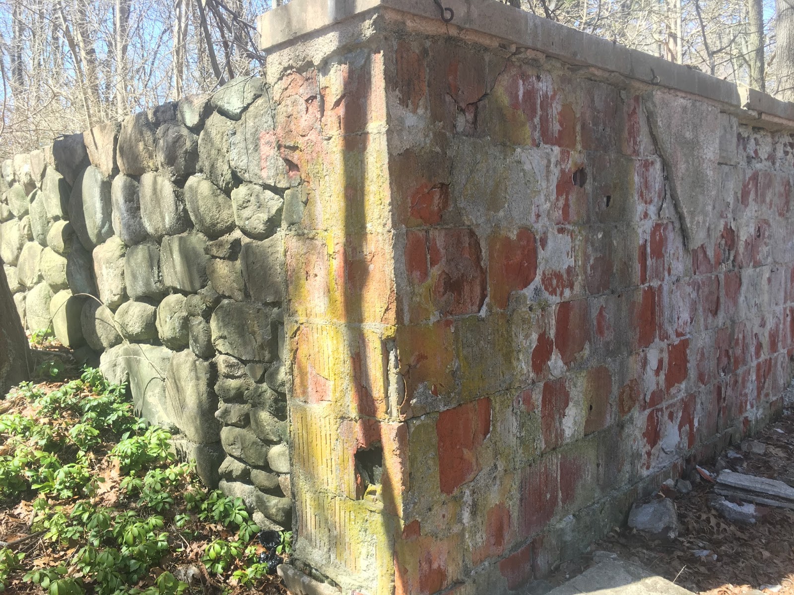
Not too far into the woods was this chamber, and my initial thought was that we were looking at an opened and abandoned crypt.
Anyone who has spent time in New Hampshire is familiar with the countless small cemeteries that line our roads and are hidden within our woods. Many are family plots with only a handful of markers, and it's not uncommon to see one that has a crypt build into the hillside. Marked by a break in the stone wall and with its half-size doorway that is what this looked like from a distance, and although I'm personally not keen on seeing a 200 year old decomposing corpse, we walked over to take a look.
As a disappointment to one of us there were no corpses inside, but that doesn't mean it was empty. What we found was evidence that someone had probably spent a lot of time in there - and possibly even lived in it - starting with this ratty old sleeping bag that barely looked warm enough for our months of July and August. The bamboo fixture on top is the base of papasan chair, which all things considered could actually have been quite cozy in here.
And these boards might even have served as a jailhouse cot for the owner of the sleeping bag.
I'm making a couple assumptions in the course of writing this. First, that this isn't the remains of some old basement and that it was in fact a crypt. Although my head leans toward the basement theory my heart is sticking with it being a crypt, for Tina's sake if nothing else. My second assumption is that someone was actually living in here and not just camping out for a night or using the place to dump some garbage. It's a possibility, but certain toiletries outside - the likes of which you'd be thankful I didn't take pictures of - make me think someone did spend a fair amount of time in here.
If that is true, then wherever this person is today I hope they're in a much better place now than they were back then.
When considering new adventures to go on I like to balance the amount of hiking needed against the amount of cool stuff we'll get to see once we arrive. The hike is often a necessity of exploration, not just because most of the good places are hidden from the public, but for the same reason a cold beer always tastes better following an afternoon of mowing the lawn. Things are more enjoyable when you have to work for them first.
The JC Phillips Nature Preserve of Beverly Massachusetts hits that sweet spot with just the right balance of hiking and exploring. It's located behind the historical Moraine Farm, which is where this adventure begins nearly 140 years ago. John Charles "JC" Phillips, a businessman from Boston, purchased 275 acres with the intent of creating both a future logging site and a working farm. Only problem was, this 275 acres was a wasteland that was as barren of vegetation as the top of my head is barren of hair. But for a problem solver such as JC this was no biggie, he simply rerouted 40 acres of drainage, planted 60,000 trees, and terra-formed the entire land into a farm that is still in operation today. JC passed away in 1885 but the land remained in the family, and in the early 1900's one of his children, William Phillips, built a mansion he dubbed Highover Estate in the woods of the property. Highover burned down in 1968, and that brings us to present day 2017 when we set out to hike this area and find the remains of the estate for ourselves.
If you drew a circle around the preserve Highover would be the bulls-eye, so in the spirit of balancing work and play we took the long way around to first enjoy the sights of bordering Wendham Lake. This is a spring fed lake that produces ice so pure it was harvested each winter and packed in straw to be shipped worldwide, a business that continued into the 1930's. With such a nice view you'd think I'd have a picture or two of the water, but twice through my photo album says this peek in the background is the best I've got.
During the hike we did get a couple good action videos, because it just wouldn't be a hike if we didn't risk breaking a tailbone now and then. I chose to risk mine by showing off my tight-roping skills on this toppled tree.
This teepee structure was curious, and I liked imagining it was a communal effort where each person to come along would add another log to it. I also liked imagining I was going to have to crawl inside and rescue Tina, but she managed to find her way out.
After some helpful directions from a trail-jogger we started coming across remnants of the burned down mansion. First it was a solitary stone pillar, then some random steps, and finally on top of Prospect Hill we reached our destination, the beginning of Highover ruins.
I've seen pictures of the original mansion and my best guess is this was the courtyard in the rear. It is also the structure that convinced me to make this hike when I first came across it online, so I was happy to find it still standing where we could get a few pictures with it.
Another spot that held up over time is this archway. I can't figure out it's purpose other than just being decorative since a brick wall stands behind it, but be sure to look for the Latin writing carved into the rounded stone at its base.
This corner where two walls meet was another head-scratcher, almost like each of them was built in different eras. Or maybe on different budgets, not unlike the sunroom we tore off our house a few years back.
Also, we've come across some pretty creepy things in our years of explorations, but this gargoyle fountain is right at the top of that list. Look close and you'll see that it's still spitting out water.
85 acres of the original Moraine Farm are owned today by the cities of Beverly and Wenham, under an arrangement that protects the land from any development. The area is open to the public, and a kiosk at the site of Highover ruins offers further history of the property and former mansion. For anyone looking to make an enjoyable hike and explore a piece of history, I highly recommend you spend an afternoon at the JC Phillips Preserve.
Just make sure you walk the long way to get to the ruins.
Among the many Devil's Dens, the cave at Barrington is one of the most remarkable. It has, probably, the longest underground chamber in New Hampshire, not man-made.
- New England's Buried Treasure, 1946, Clay Perry
New Hampshire isn't exactly riddled with caves, but this was still a bold claim. The longest natural underground chamber in the state, and not hidden somewhere in the White Mountains but rather an anonymous 400 foot hill in the little town of Barrington? Finding this spot had been on my wish list for a while now, but until recently the only clue I had was that the cave was located about a mile northeast of a well known landmark in town. I didn't imagine this meant an exact mile or an exact northeast either, which made a pretty wide area of woods when I started scoping it out on Google Earth. I saw many afternoons of fruitlessly searching in my future.
That's when my fortune changed and through discussions with a fellow adventurer I was given specific coordinates to its entrance. In return I happily offered him the location of any place I knew of, and soon after made my first scouting mission to the area. I found a trail off Route 9 that led in the general direction of the cave, so my plan for that weekend was to ride my bike as far down the trail as it would take me, then bushwhack the rest of the way.
The first part of this adventure was not only easy, it was surprisingly interesting. The trail turned out to be an old dirt road that led past several interesting sights I'd like to learn more about, starting with these stairs that led to nowhere.
I eventually reached the end of both the trail and all signs of civilization, gave my GPS a stern warning to accurately record the location of the tree I was chaining my bike to, and there I began my bushwhack. As the crow flies the distance from my stashed bike to the cave's entrance and back was roughly a mile, but I don't have wings and the route I hiked took me 2.83 miles round-trip that afternoon, a good majority of it being not very pleasant. The nastiest part was crossing this marsh, and if you're from New Hampshire I don't need to tell you that swamp water in early May is something less than a warm bath. I came out of that thing with a worse case of trench foot than Gary Dodds, but on I pressed.
During most of my adventures there comes a time when doubt sets in as to whether I'll succeed, and today was no different. After reaching the spot my GPS insisted the cave was but not finding any big holes, I had my first wave of concern. Not panic though, I simply expanded my search to a wider circle and tried again, including scouring an area with several massive boulders that I thought had to be the spot. But I still found nothing, and that's when I did something that has since made me a firm believer in the term temporary insanity. I turned off my phone and my GPS, put my electronics in my pockets, then looked around and thought to myself; if I were a cave, where would I be? And I began to walk.
Twenty minutes later I stood alone in the wood, no idea where I was and feeling more than a bit foolish. I'd just tried to outsmart a satellite GPS using nothing but my sixth sense. But before I never speak of that craziness again, let me say that two good things came of it. One, my wanderings led me to this small cabin perched overlooking a lake, which reminded me of a scouting camp I'd explored the previous fall.
The second cool thing that came of it, depending on your view of this stuff, were these two jawbones I spotted while retracing my steps. I'm no zoologist, but by the size of these things I'm leaning toward them belonging to a moose. Or a bigfoot.
So I decided to give the coordinates another go and fired up my GPS again, and I don't know what was suddenly so different - maybe that I was coming at it from the opposite direction, or maybe my Garmin was jumping on the first try - but this time I hiked right up to the cave's entrance as if I'd been there a dozen times before.
Now came the next challenge, making sure nothing was waiting inside to make me its post-hibernation breakfast. I raised all sorts of hell at the entrance, including chucking several stick and rocks down into the darkness, then waited a good fifteen minutes without hearing any noises from within. Knowing there's no guarantees when it comes to stuff like this but hoping that anything inside was more scared of me than I was of it, I crawled in.
The first ten feet felt like I was shimmying down a kid's tube slide I was too big for, then the cave opened to a hallway maybe twenty feet in length and with a ledge running through the second half of it. It was as impressive in size as Clay Perry's 1946 book described it to be. After a moment of thanks that I'd worn old sneakers, I crossed a stretch of animal droppings deep and squishy enough to almost flat-tire my shoes, then I was able to climb onto the ledge and reach the end of the first chamber.
From here the hallway dropped through another chute, and although I'm confident I could have squeezed through and continued into a second more narrow chamber, this is where I stopped for the day.
As with prior explorations, if I'm not certain I can make it through safely I'll wait for a return trip with friends.
So I left one of the foreign coins I carry on a ledge at the end of the first chamber, then triumphantly made my way back out into sunlight. And for anyone who reads this story, if you somehow find yourself in that cave someday and are able to locate that coin, I really do hope I hear from you.
That would mean your adventure turned out to be just as successful as mine was.