Saturday, March 11, 2017

Bear Hill Tower


It's fitting to me that a town by the name of Stoneham would be home to a stone tower that looks straight out of medieval Europe. Welcome to the Bear Hill Tower of Stoneham, Massachusetts.

Located within Middlesex Fells, a 2,500 acre reservation criss-crossed with hiking and mountain bike trails, Bear Hill Tower was constructed in 1910 on a 319 foot elevation as an observational tower. It's actually the second tower built on this site as a replacement for an original one built by the Appalachian Mountain Club, and is perhaps one of the lesser known locations on the Massachusetts list of historical places.

Driving to the reservation was a bit confusing as we had to enter a small industrial park to find the trailhead. We were almost convinced our directions had led us to the wrong area, but after a couple testy exchanges with Siri we found our spot, a small parking area to the left of the first building in the park. From there we started our half-mile hike to the tower.

I've read that the the Bear Hill Tower is sometimes locked, but I don't know this for a fact since this gate was wide open the day we visited. Or, maybe Tina picked the lock with one of her bobby pins while I wasn't looking.

My suspicion is that the tower used to be locked but is no longer maintained, a suspicion I base on the large tree that's been allowed to grow and obscure the front of the tower. That feels to me like a place nobody is looking after. But provided you're lucky enough to enter it like we were, you'll find yourself climbing a tight, circular stairway that starts with cement steps before changing to these more narrow wooden planks. Also, Dramamine makes a person brave, notice the 2 missing rails where Tina stood to take this picture.

Make your way up its 4 winding levels and you'll be rewarded with a view that stretches all the way from New Hampshire to Boston. Squint past the glare of my forehead and you'll see the Boston skyline in the background of our picture.

This was our last stop for the day on a whirlwind visit to several sites in Boston, so luckily it was a very easy hike. Next time you're looking for something not too challenging that has a very cool payoff at the end, take an afternoon and make the one-mile loop up Bear Hill in Stoneham.


Links:
Coordinates of Bear Hill Tower

Friday, March 3, 2017

On The Hunt For Abandoned Vehicles


What's better than spending a day hiking in the woods? Spending a day hiking in the woods where there's a payoff at the end, which for us lately has been some pretty cool abandoned vehicles.

I'll start with our adventure last fall to the Mill Pond Conservation in Burlington Massachusetts, where the biggest challenge of the day was figuring out where to park. We didn't know much about the place other than two things - it was a conservation area, and there was an abandoned truck somewhere in those woods. We weren't even sure if the area had walking trails though, and after circling the surrounding neighborhoods a few times - to the point we were getting longer than casual looks from some residents - we weren't even sure there was an entrance. Houses seemed to border the conservation's entire 140 acres.

But fortunately I make a habit out of "yupping" my wife, because long after she'd told me to give up searching I found a small parking area at the end of Makechnie Road, where we entered the woods. And after an enjoyable and not too long hike we found the prize, this rusted heap that barely had the words "Burlington" something or other written on the door.


Next we'll bring you to College Woods here in Durham New Hampshire, another easy and enjoyable hike we made this winter. That is, enjoyable until I took us a half mile off-trail and into snow and slush and across a small stream that our hiking shoes were totally unprepared for. After several white lies where I told Tina to keep moving because our destination was "just over the next hill", we finally did come over the next hill and find what I was looking for, this beast that some company dumped long enough ago for trees to have grown around it.


While driving through Berwick Maine one afternoon we pulled over to check directions and noticed a dead-end dirt road disappearing into the woods. Abiding by our family rule of never letting a dead-end dirt road go unexplored (a family rule I created at that very moment), down it we went. Although in itself the road was unremarkable I spotted something through the trees, and to the synchronized eye-rolling of my two youngest children had Tina pull over. There I crept through the woods and snapped pictures of this stripped down old relic.

This next spot brings us back to Massachusetts, and on a hunt through a former farm turned conservation area. The cars we found in these woods were a real windfall - three old Saabs the likes of which I've never seen on the roads of New England.

One being this mini station wagon. I've never seen Tina look large next to any vehicle other than her Big Wheel.

Our final abandoned vehicle I'm adding for two reasons. First, it's a model I'd never heard of before and thought it had a cool name, a Plymouth Scamp. Second, this car is a piece of a much bigger puzzle, the disappearance of Sorensen Transportation and 39 of their tractor trailers that were abandoned in the woods of New England many years ago. This caused quite an Internet buzz when pieces of the story came out last year. Their location was kept secret, but Barry and I found clues to their whereabouts and took this picture while on the hunt to find these trucks for ourselves.

Stay tuned!

Friday, February 17, 2017

Tilton Arch - An Empty Tomb


Tilton New Hampshire was incorporated in 1869 and named after local businessman and resident Nathaniel Tilton. Nathaniel had a grandson named Charles, and Charles loved the town that was named after his family. He also had lots of money, and because of this was able to gift the town with luxuries such as statues and paved roads.

When Charles Tilton traveled to Rome in 1881 he visited the Arch of Titus, and was so impressed he decided it was just the thing his hometown in New Hampshire was missing. So upon his return he constructed this 55' tall replica known as the Tilton Arch.

Tilton Arch stands at the peak of a 150' hilltop, uphill from Arch Cemetery, and is surrounded by a well kept park. Access is free and makes for a perfect area to let the kids run around while you stand in awe of this monument, and if you're anything like me you'll spend several minutes doing just that. I'm not sure there's a more impressive structure in all of New Hampshire. My first time visiting I was alone but wanted to get a picture to show its size, so I waited near the cemetery for these two cooperative guys to wander up.

Rome's Arch of Titus is a monument to celebrate war, specifically the ransacking of Jerusalem during the Jewish War in Judaea. Tilton Arch is a monument to celebrate peace, specifically the "Victories of Peace rather than those of war", as dedicated by Charles Tilton. Some of the good feeling that gives you might drop a notch when learning that Charles built the arch over the former site of a Native American fort, but in those days before political correctness that didn't seem to faze anybody.

Inside the arch Charles placed a time capsule consisting of gold and silver coins, newspapers from as far away as Boston, and a book titled "Successful Men of New Hampshire" which I'm guessing contained a few entries for men with the last name Tilton. Then he added this 50-ton sarcophagus and granite lion in which Charles intended to be buried.

But here's where I start scratching my head. Charles didn't actually build the arch within the town of Tilton. He built it in the neighboring community of Northfield where it stood in view of his mansion, under the belief that Northfield would soon be incorporated into Tilton. That never happened, so upon his death Charles forsook his arch and chose to be buried in a cemetery within the town limits of Tilton, and under much more modest conditions.

Which means that not only does Tilton Arch stand forever empty, it stands forever in the wrong town.
Logan doing his best to "conquer" the Tilton Arch

Links:
Tilton's Triumphal Arch - NY Times, 1883

Saturday, February 11, 2017

Mount Agamenticus


From its various uses as a military outpost, then its recreational span as a ski resort, and now to its modern popularity as a hiking conservation, Maine's Mount Agamenticus has long been synonymous with this region of New England. On a mild afternoon in the fall of 2016 we made our long overdue hike there.

This area offers 40+ miles of trails but its "peaks" are of the 500 foot variety, so knowing this was not a strenuous hike we were able to talk our kids into joining us. Together with some friends we started up the outer loop section of trails with the dummy proof plan of taking a right at every intersection, figuring we might end up back at the car but at least we wouldn't get lost. This outer loop consisted of trails named the Ring Trail, Porcupine Trail, and Tina's personal favorite, Rocky Road. She said it reminded her that we needed to pick up ice-cream on the way home.

After an enjoyable mile and a half hike, where at one point we even felt like we were going more downhill than up, we found ourselves standing on peak #2. Here is Logan, who doesn't just climb mountains he conquers them.

From there we backtracked and headed for peak #1, where all the action took place in the mountain's early years. In 1940 America's first radar tower was constructed on this spot and 25 men were stationed in barracks. Additionally, a fire tower that was built in 1918 saw usefulness during this time of war as a lookout tower peering over the Atlantic. This was a short lived outpost which burned down in 1944, and with WWII ending it was not rebuilt. The fire tower remained and in 1981 was replaced with a newer model that is still there today. It was a 60-foot tease to us however, since unlike the towers we have in New Hampshire this one is gated off-limits to the public, even though it's still in use and presumably safe.
Following its short stint as a military hill, Mt Agamenticus then opened as a ski resort in 1964 under the name “The Big A”. Unlike the larger mountains up north where snow is more plentiful, The Big A suffered from low snowfall and shut down after just 9 years, leaving several former ski trails to morph into the hiking paths we enjoy today. Happily, other remnants of its former life remain and make for some good exploring. Like Logan on the mountaintop, I don't just explore old remains, I conquer them.

If scenic views are your thing you probably want to head straight for peak #1, where the view is beautiful for nearly 360 degrees. On the cement base where the radio tower used to stand is now this lookout deck, our final stop for the day.

Whether you're looking for a beginner's hike or a grueling day-long excursion, Mt Agamenticus has something for everyone and easily satisfied our desire for adventure that day. How much did we enjoy Mt Agamenticus? Rather than try to put it into words, I'll simply show you Tina at the end of the day as she was saying goodbye to the final trail.


Links:
The Mount Agamenticus Conservation Region

Saturday, February 4, 2017

Devil's Den Cave in New Durham


I'm not sure what New Hampshire has less of; caves in the wild, or originality when naming our caves in the wild. This summer we plan on searching for Devil's Den Cave in Barrington, last summer we explored Devil's Den Cave in Pawtuckaway State Park, and this weekend we successfully located Devil's Den Cave in New Durham. In New Hampshire at least, the devil is a bigger real estate mogul than Donald Trump.

We made the trek to Devil's Den New Durham over a layer of snow just crispy enough to support every other step. The first half of our hike offered some cool sights, such as the beginnings of this fort some half-ambitious person started constructing out of life-sized lincoln logs.


Soon after we veered off the main course and up a winding trail I believed would shortcut us to the cave. Red marks began appearing on trees, which seemed like a pretty good indication we were headed to something devil related. A mile later we arrived at a cliff which from there our directions said to follow to the right. I had done a good job getting us to this point, but if not for Tina spotting this partly-hidden arrow under the snow I would had led us right past the cave and possibly to a day of futile searching.

Devil's Den Cave is a narrow crevice formed between two giant slabs of rock, and the entrance requires you to hop into this hole and butt-slide your way through the opening.

When faced with daunting challenges such as this in our adventures, we usually proceed in order of common sense and start with the least. So into the hole I went.

Flashlight in hand, I wormed my way into the cave and was greeted with this surprise - through an entrance I had struggled to fit my body someone had maneuvered this wooden ladder. It was aged - some of the rungs were broken and replaced by rope, plus it had come unattached from the rock - but by bracing my body against the far wall I made it to the bottom and took this picture of Tina testing out the ladder herself.

I was impressed she'd made it this far but Tina had no desire to test the sturdiness of the remaining wooden rungs, so I began my trek to the far side of the cave alone. Devil's Den is much too narrow to walk along the bottom, so the only way across is higher up along various ledges such as this one on the left.

Which were just wide enough for me to balance-beam my way across.


Fortunately an opening on the far side of the cave meant I could exit there, and I emerged triumphantly having conquered version #2 of Devil's Den New Hampshire.

Even if the possibility of climbing into a hole and getting wedged underground like a cork doesn't excite you, this is a great area to hike and well worth an afternoon just to see the cliffs.

Maybe for our next trip I'll even get Tina to repel down one of them. Of course, I would have to go first.

Saturday, January 28, 2017

The Sphinx and Mt. Auburn Cemetery


"It seems as if Nature had formed the spot with a distinct idea in view of its being a resting place for her children, where wearied & disappointed they might stretch themselves beneath the spreading cypress & close their eyes "calmly as to a nights repose or flowers at set of sun."
- Emily Dickinson, 1846, describing Mount Auburn in a letter to a friend

This spring when the weather turns nice and you're looking for a new place to explore, try spending a day at the Mt. Auburn Cemetery in Cambridge Massachusetts. That's right, spend a day exploring a cemetery.

Actually, the first thing to know is that Mt. Auburn is not just "a cemetery". In 1831 it became the United States' first rural cemetery, fashioned after those that had begun cropping up in Europe 30 years before. The main ideas of rural cemeteries are that they aren't associated with any church and are therefore nondenominational, and (more importantly to me) they are created as a garden style public park that is meant to be enjoyed. Mt. Auburn Cemetery features 170 acres of of roads and pathways that total more than 10 miles in length, and is adorned with over 700 species of trees and thousand of bushes. It also features some of the most magnificent tombstones, memorials, and chapels I've found in New England.

These are all impressive facts which Tina and I knew very little of when we visited Mt. Auburn in the summer of 2016, we only knew the cemetery was said to have some pretty cool gravestones. So while in Boston one day we decided it would be a good place to eat lunch while maybe spending a half hour or so checking out. We arrived and quickly learned our mistake. Mt. Auburn is not the type of place you can just "check out" for half an hour, it's the type of place you need to spend the day and experience.

Here's an example of us putting ourselves in a too rushed a position to properly enjoy Mt. Auburn. Flipping through my pictures I found this beautifully carved dog and I don't even know if he is overseeing a single grave or a family plot. If we'd not been so pressed for time and had stopped to look, I'd not only know his story but probably would have a half-dozen pictures of Tina scruffing his ears and telling him he's "such a good boy!"
This angel statue, which could be the highlight of many other cemeteries, almost gets lost in all the beauty Mt. Auburn has to offer.

Our greatest surprise of the day was that Mt. Auburn is not only a cemetery, but a memorial park as well. We found this out coming around a corner and seeing this giant sphinx. I was slightly bummed it wasn't guarding the mummified corpse of some Egyptian Pharaoh, but instead it is a civil war memorial. Off the top of my head I don't recall what role Egypt played in our country's civil war, but it was amazing nonetheless.

Another memorial is the Washington Tower, named after our first president and located on the highest knoll within Mt. Auburn. Climb the 62 feet to its top platform and you'll be rewarded with an overview of the cemetery and the Boston skyline in the distance.

Beyond all these amazing sights, Mt Auburn is still a cemetery and they do still frown on certain things. Like grave robbing. Tina.

I have dozens more pictures of the spectacular things at Mt. Auburn which I actually forced myself to withhold from this post. I wouldn't want to spoil all the fun, and instead encourage you to visit the cemetery and experience it all for yourself.

Links:
Directions to Mt. Auburn Cemetery

Saturday, January 21, 2017

Forbidden Files - Family Hike to an Abandoned Train


Some families spend a beautiful summer's day wandering through the mall, while other families spend a beautiful summer's day hiking through the woods in search of an abandoned train.

No need to tell you which category we fall into, I'll just jump right into the story.

From bits of info I gathered off the Internet, including a YouTube video and NPR article, I knew that a half-dozen train cars were abandoned somewhere in the woods of New Hampshire. Their location was never given but I did know what city they were in, so off I went to one of my favorite friends in these types of situations - Google Earth. Three beers later I was confident enough I'd spotted them that I planned a trip with family and friends for that weekend, and on a blistering Sunday morning we made the 2-hour drive to hunt them down.

We met at a railroad crossing nearest to where we planned on entering the woods, gathered up our survival gear (waters for all of us plus goldfish for the youngsters), and feeling much like the kids in the movie Stand By Me we began hiking the tracks.

Unlike the challenge of trying to find something you could walk right past without spotting (like an elusive man-made cave), the only question on this day was whether we were headed in the right direction. As long as we were we'd be guaranteed to find the train.

And in less time than I expected this question was answered.


Six cars made up this abandoned train, with three being open wagons that still had traces of cargo in them. The one below carried both rocks and mischievous boys - one in front of the camera and one behind it. That night I googled the serial number of this car and learned it was built in 1941 and came with the chuckle-inducing name of a "bottom dump".

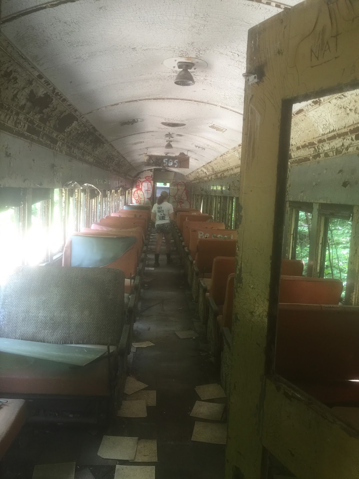
Besides that tidbit of information I don't know any other history of the train, so instead I'll share some pictures. We climbed aboard a passenger car which in its day must have been state of the art, but was now just a shell of its former glory.


This was Madison walking the aisle of another passenger car as if trying to remember where her seat is. She told me to make her look "wistful" in this picture.

And here's a shot of the overhead compartments. Never mind a suitcase, you'd be lucky to fit just your toiletries into one of them.


With a bit of muscle some of the benches still actually worked. They could either all be facing forward, or you could pull a lever and flip the back so that every other bench was facing each other.

Logan found a seat at the front of the train that looked like it came with some importance, so of course he claimed that as "his spot".


To answer a couple of questions about this trip, yes the tracks we were walking down are active tracks in the summertime, and no we probably should not have been in this area. But we were careful of our surroundings, respectful of the property, took nothing but pictures and left nothing but footprints.

Which made this one of the more memorable ways I've ever spent a beautiful summer's day with the family.

Friday, January 6, 2017

Our Alice


Make a particular half-mile hike into the woods of Barrington and you will find this old cellar foundation, one of hundreds that exist throughout the woods of New Hampshire.


But while at first glance this might seem like just another place where a house used to stand, one thing differentiates it from any other foundation I've come across. This one has a gravestone in the middle of it.

The stone belongs to Alice L. who died in 1863 at 11 months and 10 days of age, details which are listed on one side of the gravestone. On the other side is the simple yet loving phrase; Our Alice.

What does it mean that this gravestone stands alone within these walls? My first thought was the obvious one. Most people in the 1800's didn't have much money, which I assumed was the case here, and so I guessed the family buried their infant girl in the basement of their house because they couldn't afford a plot. Then over time the house was destroyed and only the things that were made of stone - the house foundation and the headstone - remained.

That is one possibility, but then the question becomes how could they have afforded the headstone if they had no money?

A second possibility is that the gravestone was maliciously placed in this spot. If you walk about 300 feet deeper into the woods you will find a family graveyard with roughly a dozen gravestones, ranging from small chunks of rock to full-size slabs. Many are toppled or in various states of decay, and the popular theory is that Alice's gravestone was moved from this nearby graveyard to the middle of the foundation. But since the graveyard was cataloged in its current condition 40 years ago, it had to have happened sometime prior to that.


I hate the idea of anyone's gravestone being vandalized, but if that's what happened I'm at least happy that Alice's headstone - perhaps due to its location and the extra attention it's been given - has endured in better condition than many of those remaining in the family's forgotten graveyard.
Our Alice can be found along Tibbets Trail in the Atlantic White Cedar Swamp