Tuesday, August 30, 2016

Dungeon Rock Cave & Pirate Veal's Treasure


In Lynn Massachusetts once lived a man named Hiram Marble, and in 1852 Hiram had a vision. In this vision the spirit of Thomas Veal, a pirate who centuries earlier had fled into the Lynn woods after 3 of his cohorts were captured and hanged, told Hiram to dig inside a small cave in the Lynn woods and he'd become a rich man. Convinced this vision was real and the spirit was directing him to his hidden bounty, that year began Hiram's lifelong quest for the search of Pirate Veal's treasure.

Hiram moved into the woods where this cave existed, and for a while he actually lived inside it. Later he built a house at the bottom of the hill into which he moved his wife and son. In Hiram's search for the treasure he spent each day digging deeper and deeper into the cave, carrying out the rubble by hand. Even after many years passed without finding anything he was just stubborn enough, or crazy enough, to keep at it. He died in 1868 having spent the final 16 years of his life digging in vain.

That might have been the end of the search, but crazy didn't skip a generation in the Marble household. Hiram's son Edwin, who had already been helping out with the search, continued digging right where his father left off. In 1880 he too died unsuccessfully, and so ended a quest that had begun 28 years earlier and ended with a giant hole in the hill.

This hole still exists today and is now known as Dungeon Rock Cave. A steel door was installed at its entrance, however the door is opened for the public from 9am to 2:30pm every Tuesday thru Saturday. Access is free and only requires an easy hike of around half a mile to reach it. We made this hike on a steamy afternoon this summer, and after reaching the hill ascended via this neat little staircase cut into the rocks.

With a little bit of poking around it was easy to locate the cave, and we were pleased to find that sure enough, a park worker does actually make the trip out there each day to unlock the door. After triumphantly posing for pictures at the entrance Tina and I made our way in.

What I expected to walk into was a hollowed out cavern maybe the size of a small room, but what greeted us was an actual mine shaft, and quite a long one at that. We started our journey by descending this set of stairs someone so helpfully installed.
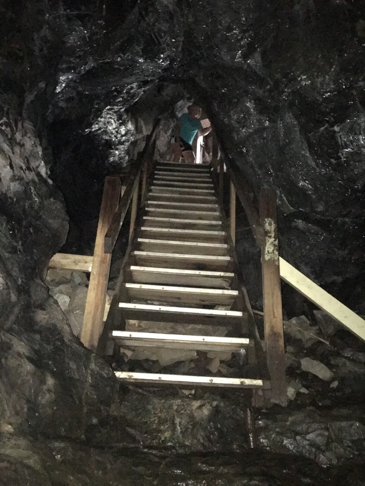
The cave wound back and forth throughout its entire length, never actually going in a straight line, which legend says was due to the spirit constantly "correcting" Hiram's direction. I estimated it's length to be between 100-150 feet, mighty impressive for 2 men to dig without using any machinery.

Nearing the end we felt the tunnel's ceiling getting steadily lower, and I could almost sense Hiram's, or at that point probably Edwin's, desperation to hurry up and dig farther and quicker as time ran short. The tunnel ended in an equally desperate manner, for the first time splitting into two directions and each continuing only a handful of feet at a crawlspaces height - a last ditch change of direction the son didn't quite have time to make.

We left that day thinking pretty much the same thing we did as when we started, poor old crazy Hiram Marble. We pitied him for wasting his life like he did. But later on we learned something about the man that got me wondering. While he was digging he would charge locals for tours of his tunnel, and additionally he sold bonds for a stake in the treasure once he found it. This subsidized his quest to continue doing what he loved, digging for riches, a desire he passed onto his son so strongly that his final wish was to be buried in the ground right outside the cave.

I'm typing these words on a beautiful summer day while stuck inside an office, finishing my lunch break so I can get back to earning my living shuffling papers around a desk. Hiram, on the other hand, earned his living by going on a life-long hunt for pirate's treasure.

Now I'm wondering if I've had it backwards all along. Perhaps it's Hiram who would have felt pity for me.

Wednesday, August 24, 2016

The Forgotten Village of Punkintown


Nestled deep within the woods of Eliot Maine once lived a community of 30-40 people, existing self-sufficiently and separate from the surrounding cities of Eliot and South Berwick. This was known as Punkintown Village. At its height in the 1800's it included anywhere from 7 to 10 families, at least one quarry where they cut stone for their house foundations, and their own grist mill for processing grain. This village survived into the early 1900's until a series of fires and illnesses led to its demise. The woods overtook what remained of the village, and today not a single signpost or marker stands that would point you to where it once stood.

Internet research hasn't been much more productive, with the most entertaining piece of information being the legend of cross-eyed Emma Jane, one of the last inhabitants who would walk into neighboring South Berwick to steal food from gardens and try to sell it back to the townsfolk.

So off we went one Saturday afternoon to try and find the village for ourselves. Our hike began on a dirt road off Route 236, where a trail would supposedly lead us to a pair of lakes the village once sat between. Sure enough, an unmarked trail continued uphill at the end of this dirt road. There were several side paths along the way, but we stuck to the main trail as we believed this was the original horse & buggy "road" that led to Punkintown Village.

Perhaps half a mile into our walk we found this memorial stone, and although nothing about it indicated Punkintown we at least felt we were on the path to somewhere.

Next we came across 3 of these stone pillars, which we thought might be markers of some sort. But although we scoured the area pretty thoroughly we found nothing else of interest nearby.

After a mile of walking what finally suggested to us we had reached the village was this cellar hole. It was set back from the main path and you had to be looking to spot it amidst all the growth, but it was unmistakable once you did.

We reached the end of the main trail without any further discoveries, but many side paths still needed to be explored. The bugs were attacking pretty fiercely though, so we decided that Tina and Logan would return to the car while Barry and I each picked a trail to walk 5 minutes down. It was a last ditch effort to find anything else.

I was perhaps 60 seconds down my trail when I struck gold, coming across the remains of this old cemetery.

It was the Plaisted family cemetery, which I'd remembered reading to be one of the families that inhabited Punkintown Village. It was run down but wonderful, standing alone in the middle of the woods as it was. Like many family cemeteries this one has a large memorial in the center listing each family member,

And many smaller stones with brief descriptions of who was buried underneath, such as this one simply labeled "mother". I can only hope my kids give me something equally as loving when I die.

Finding this cemetery made the entire afternoon worthwhile, and has encouraged us to make subsequent trips back to explore more of the side trails. In three follow up visits we have found another house foundation, a quarry, this fully standing structure,

and this partially standing one.

And although information has been scarce, I did find a reference online that spoke about the remnants of the village, and of its cemeteries. Plural.

Which means there's still more treasure to be found in the woods of Punkintown.

Sunday, August 14, 2016

Parker Mountain Plane Crash Wreckage


In 1946 a twin-engine airplane crashed into the side of Parker Mountain in Strafford NH, killing all three people onboard. All these years later pieces of the plane still remain on the mountainside, and on a drizzly afternoon in 2016 I took Logan and a friend in search of the wreckage.

Occupants of the airplane were millionaire Leslie LeVeque, his wife Elsa, and pilot Robert Johns, all of Columbus Ohio. In addition to being a real estate investor and co-owner of the then tallest building in Columbus, the Lincoln Tower, Leslie was the inventor of the automatic pinsetter used in bowling alleys. The couple were returning from a weekend at their summer home in Blue Hill Missouri when, according to the Marysville Tribune of Ohio, a lack of visibility due to dense fog caused them to hit the mountain.

From researching the site I knew the wreckage was on the north face of the mountain, but unlike other crash sites there was no trail leading to it. At least none that we found. Nor were there any discrete little ribbons tied to trees that point the way, such as those at the Belknap crash site. But Parker isn't a very big mountain, so with a general idea of the location and a little bit of stumbling we were able to find what's left of the plane.

There's a feeling I get when hiking to one of these crash sites, at the moment the wreckage first comes into view, when reality hits that I'm witnessing a spot where something bad happened. The look on Logan's face when he first spotted a piece of the plane sums up that feeling perfectly.

I had read there were three large pieces on the mountain, however we were only able to find two of them. One was this twisted piece of metal here.

And the other was what looked to my non-aviational eye to be the front of the plane.

After visiting the crash site we made out way back to the main trail, which we followed to the top of the mountain. Along the way we found this rock sitting area and fire pit which, had I brought along my beer cooler I might even have taken full advantage of.

The summit of Parker Mountain isn't a full 360 view, and the clouds obscured what would have been a nice view in at least one direction, but none of that mattered on this day. It was a beautiful sight, and after my earlier thoughts about lives cut short I was able to appreciate this beauty all the much more.


Thursday, August 4, 2016

Beehive Hut and Ye Old Cemetery


The website for the town of Danville tells the story of a stone chamber, rumored to exist somewhere within the town's woods, whose location had been lost for many years until being re-discovered by some youths playing in the area. It's called the Beehive Hut and is man-made but of unknown age and origin. Speculation as to its purpose range from the mundane to the outrageous, in that it's a root cellar built by early settlers to it being an archaeological sight dating back many hundreds of years prior to Columbus.

Once it was found again, steps were taken to not only keep it found but also preserve and share it with the community. Its location down a side road off Route 111A is freely given by the town, and once you've driven as far as you can down the dirt road, arrows point you to a trail.

From where we parked it was probably a quarter mile of very easy walking until we reached the chamber.

There were no bees inside the Beehive Hut, but that afternoon it could have been called the Mosquito Hut. Those pests were everywhere. They didn't stop me from scooting in and having a quick look around though.

I even coerced Tina to step inside the entrance and take a picture.


Then we were on our way back. Once you've walked around the top of the chamber and been inside there's not much else to see. Besides, less than a mile down the road we had passed a cemetery called Ye Old Cemetery which dated back to 1740. You can't just drive by something like that without stopping to look around.


This cemetery was old to the point that the earliest graves didn't even have headstones, just rocks placed uniformly in the first few rows. When we got to the actual headstones many were broken and illegible. But of the ones we could read, in addition to giving names and dates, many had messages inscribed into them. This one from a 19 year old man started off with the cheerful phrase "Deceitful world farewell to you."

Another headstone for a "Capt. (Reuben) Hook" gave us a chuckle. I wondered what kind of ribbing this fellow took in life, however I figured out later (to my disappointment) that he pre-dated the fictional Captain Hook character from Peter Pan.

Ye Old Cemetery concluded that day's trip to Danville and the Beehive Hut. But here's what's extra cool about this stone chamber, or stone chambers in general. There are literally dozens of them in the Northeast, similar to this one and scattered anywhere from New Hampshire to New York. And there's seemingly just as many opinions as to what purpose they served as there are chambers. Most of them aren't commemorated like they've done with this one, but with some scouring we believe we have several of them pinpointed, and one of these days we'll be taking a road trip to see just how many of these mysterious chambers we're able to find.

Monday, August 1, 2016

Hammond Castle


I don't play the lottery, but if someday I ever find myself extremely wealthy I hope I do something fun with it and not just sit on the money. I want to be like John Hammond Jr of Gloucester, Massachusetts. I want to build a castle.

Building a castle might be the thing locals of Gloucester remember him best by, but John Hammond was an extremely motivated person his entire life. A world traveler who associated with people such as Thomas Edison and Alexander Graham Bell, he himself was an inventory with over 800 patents and 400 inventions to his name. His specialty was in radio waves, and he's considered by most to be the father of radio control.

Traveling throughout Europe for many years, Hammond developed a love for medieval architecture and what it represented. He was fascinated by its atmosphere, one he described as "haunting old monuments and buildings" and that "dissipated the obscurity of time." Basically, they made him feel like he'd traveled to a land long ago. Of course we all feel that way, but Hammond had enough money to do something about it. This combination of love and means, along with a need for someplace to store his vast collection of artifacts, led to the construction of Hammond Castle.

Tucked behind the trees of Hesperus Ave in Gloucester, you could almost drive right past the castle without noticing it if not for the signs and large parking lot. It's not until you're coming down the walkway that the building really starts to take shape.

Once inside the castle we were given the choice of joining a group or doing a self-guided tour. We decided to go it on our own. I've no doubt we missed some good history doing it this way, but at the same time I didn't end up with a group of people waiting impatiently when I wanted to walk up and down the hidden staircase one more time, or when I took a few extra minutes staring at a coat-of-arms and wondering if I'd fit into it.

I found the most impressive room, by sheer size alone, to be the Great Hall. Fashioned after those of the European castles Hammond visited, this hall measures 100' in length and 60' in height.

Not just the vastness was impressive, but all throughout the hall were treasures and artifacts. This human skull had no description, but researching it later we learned it is believed to belong to a sailor from Christopher Columbus's crew.

The next spot you don't want to miss is the courtyard, which is situated within the castle walls. Another reason I like Hammond is he apparently had a prankster side to him. During parties he would give guests a fright by jumping off the balcony (where this picture was taken) and into what they thought was shallow water. However this deceptive looking pool was actually almost 9' deep.

The front of the castle is the best view to really capture its size and beauty. It also provides some wonderful photo opportunities. I always drag the family into at least one of them.

Although sometimes, ones own feet can be even more captivating that a medieval castle.

The grounds are open for public access at no charge, but there is a modest fee to tour the inside of Hammond Castle. We consider this well worth the price for anyone interested in taking a trip back in time, which should be everyone. But just in case all this hasn't been enough to tempt you, know that I didn't even show you the life-size nude statue Hammond commissioned of himself for his wife, which stands by the pool.

Yet another reason why I like this fellow so much.

Links:
Official Website
Photo Album

Wednesday, July 27, 2016

Fort McClary


If I were judging local forts in the Seacoast and were to give an award for most improved in recent years, the award would go to Fort McClary.

This fort turned state park was manned all the way back to the Revolutionary War, and is located along coastal Route 103 in Kittery, a bit down the road from its larger sibling Fort Foster. I remember visiting McClary in years past when it had a boarded up, abandoned feel to it, but sometime in early 2000 a group called the Friends of Fort McClary began tending to the site, and if you pay a visit today you'll find a clean, informative park with structures to explore, cannons on display, and even officers quarters you can walk through.

There's no charge to visit the park, but there is a voluntary donation spot that I feel is well worth the contribution. Upon entering, first thing you'll see walking through the parking lot is a long cement wall. Walk around this wall and up a hill and you'll be greeted with this sight.

All those inlets in this structure once made good command posts for riflemen - easy to shoot out of, but tricky to shoot into - but nowadays they serve better as quick spots to rest and get a little relief from the sun.

This brick structure is listed as the Rifleman's House and is over 200 years old. Equally impressive, here are our two youngest kids hugging for a picture.

Evidence of what the Friends of Fort McClary have done is no more appreciable than in the next building you'll enter, the Officer's Quarters. This was once boarded up and off limits, but it's been opened and renovated and you're now able to wander all throughout it. Walk up the stairs and you'll even find this cannon, which to Logan's disappointment was not loaded.

After finishing with the buildings make your way down toward the water where you'll find even larger cannons on display.

Another cool spot was this tunnel, which from a distance looks like it's going to lead you right under water. It goes a little ways in before dead-ending at some more of those rifleman openings overlooking the water.

And like all our forts, this one comes with a wonderful view of the Atlantic Ocean.

This isn't the biggest fort we have on the Seacoast, it doesn't have the most bunkers, and there aren't as many hidden spaces to explore as others in the area. But what it does have is perhaps the best blend of all these things in one location. If anyone was new to visiting forts in the area and asked me where a good place to start is, I would direct them here, to Fort McClary.

Links:
Photo Album
Official Website

Wednesday, July 20, 2016

Sugar Hill Mines - Part One


Even though this adventure took place in the 1990's, I'm putting it out here and calling it part one because there's a part two coming up next month when we revisit the location and try to find it again. And depending on how well that goes, there may even be a special part three.

In my younger days I would go to great lengths to find adventure. I had been on a kick with exploring caves, and in my quest to find some new underground spots I started searching out abandoned mines. This was the days before Internet and having all that stuff at your fingertips, so one weekend I dragged Tina to the UNH library and we scoured historical material for any info we could find on local mines. It took some digging but the trip ended up being a success, and to this day I still have the 16 page research pamphlet on mines, locations included, that I found and photocopied at a dime per page.

Armed with this material, me and some friends began tackling the list over the following weekends, starting with the ones closest to home. The first thing we learned, much to our disappointment, was that not all mines were actual tunnels bored into the earth. Some mines are just big open pits where the walls are continually chipped farther and farther back in search of the precious stone. That's great and all from a business standpoint, but standing in a big open pit doesn't elicit very much sense of adventure. We kept at it though, and somewhere around the 3rd or 4th mine we visited was Sugar Hill.

Our first trip turned out to be no more than a scouting mission. That wasn't the plan going in, but after hiking partway up the mountain and encountering this giant hole in the earth, there was just no way to continue. We stared into that pit for probably 15 minutes trying to figure out a way down, but without rope it wasn't happening. Temporarily set back, we returned the next weekend with rope (clothesline I believe, we were no professionals) and I was the first to reach the bottom. With my old 35mm film camera I took this blurry picture looking up.

Once we were all inside we followed a mine shaft leading away from the pit, then next thing we knew we were back out in the sunlight. The shaft had led to a tall and open crevice, and at this point it looked like that might be all there was of the mine as we began a gradual climb back to the surface of the mountain. This at least saved us from having to go back and try scaling the walls of the pit to get out, which was good, but it seemed our adventure had come to somewhat of an abrupt ending.

But here's where things got fun. We found this hole in the hill, and climbing into it we found a completely separate cave system that we could only assume must originally have been tied to the mineshaft somehow. Nothing about it felt like anything to do with a mine, however - there was no structure or uniformity anywhere - but it picked up right where the mine ended. The hole to my left is the entrance to the cave.

Inside was a whole new world to explore. This was a large cavern with more than just one section, and unlike other wild caves in New Hampshire, this one also had several tall spots that didn't require ducking.
There was also a lower level which better than anything demonstrated the depths of the cave. This picture was taken in late spring, on a day warm enough for us to be hiking through the woods in t-shirts, yet here at its lowest point water remained frozen mid-stream.

Climbing out of this lower level was no easy trick. Here I am (back in the days of having hair but already showing signs of trouble), making the squeeze during a follow-up expedition.

Most of my Sugar Hill memories are limited to the pictures I have of the place, and looking through them again has excited me to make our return trip after 20+ years. I hope I'm still able to locate the entrance, and I hope the cave remains as secluded and untouched as it once was - there wasn't a beer can or hint of graffiti anywhere.

I also hope I'm still able to squeeze myself back into that lower chamber.

Links:
25 Years Later - A Return To Sugar Hill Cave

Saturday, July 16, 2016

Bethlehem Steel


Sometimes the best places I visit are the ones I'm not expecting too much out of. Maybe I'm going there because a picture or fact about it peaked my interest, or maybe I just happen to be in the area. But then it surpasses all my expectations and becomes something that will stick with me for a long time to come. Bethlehem Steel is one of those places.

We went there on our return trip from Pennsylvania and I suggested it as a stop-off mainly because the size of the place interested me, but also because it was on the same route as another place we wanted to see, Frick's Lock. Well, Frick's Lock ended up being off limits, so this meant Bethlehem Steel was going to be our only other stop on the 10 hour car ride home.

Here's what I knew about the place heading in. It was an old steel factory, it was closed for business but now open for public touring, and it was big. And by big, I mean giant! Any picture I took that day could not do justice to the sight we saw driving into Lehigh Valley and seeing this place absolutely hover over the city of Bethlehem.


After figuring out where to park and how to get into the place, our first pleasant surprise was that, even though it's been turned into a park and someone went through the cost of adding all new raised walkways, there's no charge to tour the factory. They asked just two things of us, sign the guest register and tell them where we came from. Then it was up the catwalk and off we were on our self guided tour.

We probably spent half an hour walking the length of Bethlehem Steel, reading plaques that showed old-time workers running the various pieces of machinery, and pressing buttons to listen to recordings that explained what the heck we were looking at. There were perhaps twenty of these information locations, or stopping points, throughout.

In addition to these stops and the behemoth that was the main factory, there were plenty of other cool things to see. This train was used to transport heavy loads of material to and from the factory. It's also the only train I've seen that needs to be weed-wacked.

And here's the gas blowing engine room that housed a dozen twenty-four foot flywheels.

What I came away with from the tour were two things. One, if I had studied all the information made available to us I would have left with a pretty good idea of how steel was made. But that was hard for me to do when everything was so big that all I wanted to do was look up in awe. They really did a great job explaining each process, though.

Second, and more importantly, I came away with a complete admiration for the men and women who made a living at Bethlehem Steel. The day we visited was a warm day and the heat was absolutely radiating off the place. Here I was, leisurely poking along in shorts and a t-shirt, stopping to sip water every twenty feet or so, and still I was sweating. To work up to a ten hour summer day - covered in protective gear, handling red hot molten iron, and dealing with boilers that reached 3,000 degrees in temperature - is something I'll never have to experience in my lifetime. I cannot imagine being in those conditions and having to do something like climb this 100+ foot ladder that ascends the outside of a tower, but there were days when it was somebody's job to do just that.

Those were a class of worker unlike any other, and the next time I get frustrated at my job because the copier is jammed or because someone didn't empty their k-cup from the coffee machine, I'm going to remember these men and woman who, among all Bethlehem Steel's 15 locations, regularly battled inferno conditions to produce enough steel each day to build a US battleship.

And I'm going to consider myself lucky and happily continue about my day.

Links:
Photo Album