Friday, January 24, 2020

Slayton Tower, Melrose MA


We plan most of our trips out in advance, but sometimes it's fun just to take off blindly for a place you know very little about. This was our visit to the Slayton Tower, where we made the three hour round trip based on not much more than seeing a picture of it online, and thinking it looked pretty cool. We did know it was located on a golf course, but whether it would be locked from entering, or whether the property itself would be off limits to the public, we had no idea.


Slayton Tower is located at the Mt. Hood Memorial Golf Course in Melrose, Massachusetts, but the first thing we learned is that this is actually the Mt. Hood Memorial Park and Golf Course, and that a public trail system surrounds the course. We parked just north of First Pond, where a kiosk told us how to skirt around the greens to reach the tower. Since this was December and no golf was being played - plus the fact we somehow took a wrong turn and ran out of trail - we cheated across the grass and after about fifteen minutes found ourselves climbing the high point of the park, where the tower came into sight.


But before climbing up there were a few things we wanted to check out first. In a nearby sitting area is a memorial plaque and bench honoring Major Doak A. Weston USAAF. In 1945, the B-25 bomber Weston was piloting began breaking up in mid-air. Heroically, Weston was able to keep the plane aloft long enough for his entire crew to escape by parachute, then he sacrificed his own life by crashing the plane upon this very spot, purposely away from a nearby school and houses.


As evidence that not all humans have a soul, Weston's memorial was defaced with spraypaint several years ago. Happily, it has been perfectly restored.


We also found what we believe are remnants from the days this land was privately owned - this pair of fireplaces sitting in the trees about fifty feet from each other.


Then it was on to the tower. The front gate was open, although a padlock indicated it must be locked at certain times. Round and round, we climbed our way to the top.


During WWII Slayton was used as a lookout tower for German U-boats in the Boston Harbor. Today, if your camera has a decent zoom, you can get a pretty good picture of the city's skyline.


This is a tempting time of year to stay sprawled out on the couch with a Netflix lineup and thick blanket, but when you have such cool places to explore as the Slayton Tower, it's a little easier to get outside and brave the cold during these winter months here in New England.
Photo Courtesy of a Nice Young Lady With Her Two Boys


Links:
Mt. Hood Park Website

Saturday, January 11, 2020

The Raymond Oven Cave, Raymond NH


In the north part of the town, about 100 rods from the principal road leading to Deerfield, near the summit of a hill about 100 feet high, is a natural excavation in a ledge, called the Oven, from the appearance of its mouth. It is a regular arch about five feet high and of the same width, extending into the hill about fifteen feet, and terminating in a number of fissures.


This 170 year old description of a cave hidden within a cliffside in Raymond, NH was more recently popularized in Clay Perry's 1946 book, Underground Treasures of New England". But when I first began my search for it, not a single clue to its location existed online. In fact, the only place that offered any information on it whatsoever was the letters section of the 1998 Northeastern Caver, Vol 29 No 3, in which the author had been told the cave was thought to be lost to construction. This was only a rumor, but with nothing else to go on I back-burner any further thinking about it. Then I was sent a picture by a talented fellow explorer named Chris, showing me that the cave actually did exist, and I was challenged to see if I could find it.


My first attempt started by identifying the principal road in the Gazatteer's description. From Raymond to Deerfield the obvious choice was Route 107, and I hoped this had been the case in 1849 as well. Next, Google then told that 100 rods equaled a third of a mile, so I took a drive looking for any cliffs within sight of the road, and start by exploring those. I spent an enjoyable afternoon in the woods that day, but the only interesting thing I came across was this abandoned motorcycle frame.


After looking again at Chris' picture, it seemed as if the cave had been formed by a waters flow. The Lamprey River runs parallel to Route 107, so for my next attempt I focused on undeveloped areas along the water's edge. A couple of weekend searches turned up several cool finds, but nothing that involved me crawling underground.


I wouldn't call this log cabin elaborate, but somebody put a good deal of effort into building it, even furnishing the inside with some rudimentary decorations.


My wife had joined me on this search, and the look on her face at this moment is one of both humor and disbelief. She had leaned over the well to have a peek inside, when her sunglasses dropped off her head and fell in. The good news was that it wasn't a real well - the glasses were just sitting there on the ground - but the bad news was that "man-eating spiders" prevented her from reaching inside to get them. Always the hero, I brushed aside a couple of daddy long-legs and retrieved the glasses for her.


By now we'd exhausted this section of town, so the next search was focused around a rocky ledge I'd pinpointed using Google Earth - north of 27 and west of 107. I parked where a trail followed power lines toward this ledge, then spent yet another afternoon scouring the woods. Again I came up empty, but this time I was so convinced I had the right area that I returned a week later with friends to do it again. We still didn't find it, but my camera got a good workout with all the other treasures we did come across.


Deeper in we found a few structures that I assume are used by hunters.


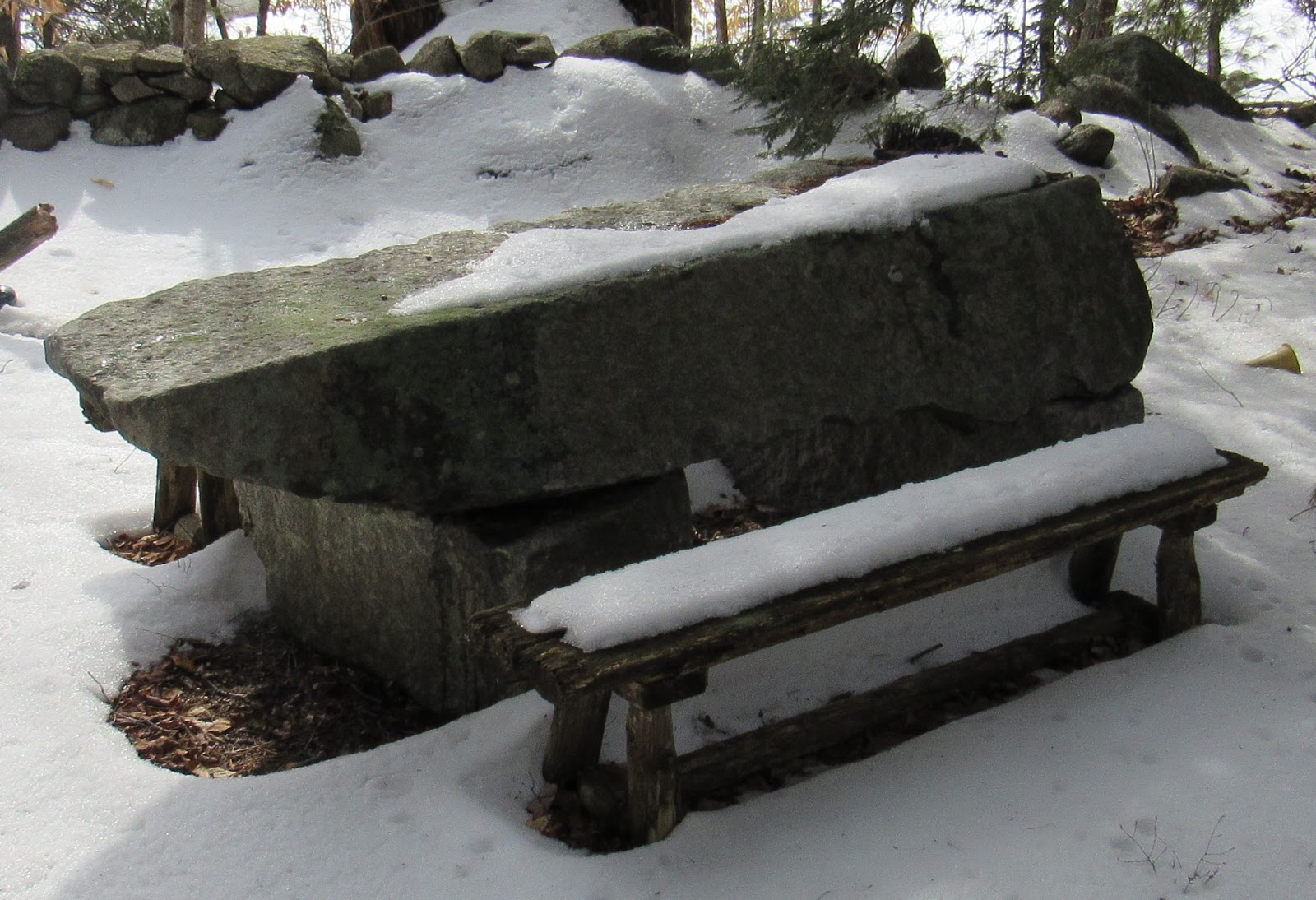
As we wandered the remains of a frisbee golf course, there was a very impressive stone picnic table.


But by the end of the day I was forced to admit that, although these woods held an abundance of cool things, this wasn't the right location for the cave, either. Back to Google Earth I went, and looking to the east this time I found a rocky location that was exactly a third of a mile from 107. The following weekend we were back at it, my sixth attempt to locate the Raymond Oven.

This ledge was separated from the road by a large marsh, leaving no direct route to reach it. We parked in a neighborhood on the opposite side, and after a 1.5 mile hike we found our second homemade cabin in the woods of Raymond.


When we reached the ledge our group of 5 split up, and the race was on. For all my frustrations and chasing dead ends in the weeks leading up to this point, my good fortune changed and I was the first to stumble upon the cave.


As with most legends, there was some exaggeration when it came to the Raymond Oven. As you can see by how I'm sitting in the opening, it is probably half that height of the five feet described in the 1849 Gazatteer.


But it did go in a ways, and we each took turns crawling inside and having a look.


It was great day out in nature spending time with friends, and pretty cool to chase down something as historical and yet little-known as this. Our friends from WeRmudfun documented the adventure on video, so click on this link and join us as we find and explore the Raymond Oven, one of the great treasures of New Hampshire, hidden within its woods.


Saturday, December 28, 2019

NH's Abandoned Transportation Museum


I enjoy those things whose creation was driven by love - built with the same mindset whether one person was going to see it or one million - which was the case with the Beaver Brook Transportation Museum in Mont Vernon. The creators of the museum, Eddie and Beth Gilbert, were buyers of opportunity for all things transportation related, and after moving up from Massachusetts they began displaying their one-of-a-kind collection at their farm. Unfortunately they closed their doors nearly ten years ago, but many of the items still remain if you are a determined explorer.


A small stream separates the property from the dirt road that takes you to Beaver Brook, and I found three entrances that cross this stream and access the museum. Two of them - the collapsing bridges below - are no longer in any condition to use, and the third way in was the property's main driveway. Rather than make myself that obvious, I hid my bike in the woods and rock-hopped across the water.


Here came the first indications that this was a transportation related place. Running parallel to the river along the property side is an overgrown trail, and within it are remnants of an old railroad. Not a full size one, but one of those tourist ones you'd see carrying visitors around an amusement park.


I followed the tracks and soon enough found a couple of the engines. The Gilbert's purchased much of their train collection from the Edaville Railroad Museum out of Massachusetts, a similar tourist spot they frequented before moving to New Hampshire.


I wasn't about to pass up the chance to hop on board and take a few pictures of myself in the conductor position.


After playing on the trains I continued up the trail through the rear of the property, and being that this was a transportation museum it was no surprise when I began finding vehicles in the woods. I could have used my dad at this point, because not only am I sure he would have known the year and model of each one of these cars, but he probably could have told me a story or two about smashing one up in his youth.


I'm still not sure what this truck was, but I left a few present on the dashboard for anyone who finds their way out here.


I'm always respectful on these explorations, and because of that I almost skipped taking a peek inside this tarped building. But I stuck my head inside the door and was glad my curiosity got the best of me.


It seemed to be a catch-all of old exhibits. Among the many items was this trolley, looking like the last thing that's still holding up the roof.


At some point the roof will win out and completely crush this thing, but I trusted it wouldn't be at this exact moment. At one time this must have been a very elegant ride.


To give you an idea of the variety of things the Gilbert's collected - and as evidence I wasn't the first explorer here - I found this broken doll propped up in a wheelchair. Why either of them were in here to begin with, I cannot imagine.


In addition to transportation there were many items related to the Gilbert's second love - Christmas. This is the kind of stocking I hope to see under our tree someday, with the name Dave written across it.


After the barn, I finished my exploration at what I consider the greatest attraction of the museum. We talked about how the Gilbert's were opportunity buyers, and when this giant Santa that once stood outside a used car dealership went up for sale, they snatched it. You can see this Santa from the dirt road leading in, so a few months later I drove my wife by here so she could take a picture with it.


I still chuckle over how anyone could combine such unrelated things as Christmas and transportation into a single, and successful, business, but there are no playbooks to follow when you're creating something purely for the enjoyment of creating it.


Links:

Beaver Brook's official page: https://web.archive.org/web/20200809025704/http://www.beaverbrookmuseum.com/

For a video tour of the museum, and where I first learned about this great place, see this video.

Saturday, December 14, 2019

Exploring the Saunders Mineshafts


The Saunders Mica Mine began operation sometime prior to 1914, and ran through a variety of companies until the site was abandoned in 1944. Two tunnels remain at the mine, which is accessible via a dirt road followed by a short bushwhack through the woods of Grafton NH.


I almost came up empty on my initial search for Saunders - also known as the Haile-Buckley Mine - after spending an entire afternoon scouring the west side of the mountain where I thought the mine was located, but not finding anything. After calling it a day I was working my way down the mountain, but rather than taking the main trail I paralleled it about a hundred yards into the woods on the off-chance I'd find anything interesting. That's when I began coming across scraps of mica and other discarded rocks, and soon after I stumbled upon the mine.


Dusk was setting in about this time, so I poked my head into a couple of crevices but didn't do any underground exploring. One tunnel was blocked by a 20-foot pool of water that all I could do was stare across at wistfully, while the other one was open but would require a bit of rock climbing to enter. Happy just to have located it, I left for home and put a return trip to Saunders on my to-do list.


It was the first of December when I made a second exploration with my buddy John. We'd purposely waited until winter so that the pool blocking tunnel #2 would be frozen over, but we should have given it another month - ice covered most of the pool, but the edges were still open. I didn't drive 4 hours that day for nothing, though. Out of my pockets came the electronics, around my waist went the rope, and cautiously I began out onto the ice. I'd made it probably five steps when the cracking started, and suddenly the bottom dropped away like I'd been standing on a dunking booth. If not for a handhold I found against the rock I'm pretty sure I'd have gone under. It was several freezing moments before I could convince my body to start breathing again, then I yelped for John to pull me out.


Water that sits for many years without moving or circulating is some pretty foul stuff, and although he's too polite to say so, I'm sure John was happy we'd driven in separate cars that day. Cold, wet, smelly, and unable to explore tunnel #2, there seemed only one logical thing left for us to do. On to tunnel #1 we went.

While flooding has made tunnel #2 inaccessible outside of winter, tunnel #1 is accessible year-round. It's approximately eighty feet long and goes straight through a small hill, however its western side was never completed and squirming is required to fully traverse it. In this picture I am entering the tunnel from the east, or the good side.


Between its narrowness and low ceiling, tunnel #1 is more suited for someone my wife's size rather than myself. Add in the abundance of loose rocks, and the feel is that you're crawling through a natural cave instead of something man-made. After a quick exploration we called it a day, and I drove the entire way home with heat blasting on my bare feet.


Three months and several cold spells later, we made a third trip to Saunders to explore the final tunnel. This time there was no issue with the ice being solid enough, I probably could have parked my car on it.


At approximately 50 feet in length, tunnel #2 measures a bit shorter than the first one, but what it lacks in length it makes up for in height. I estimated its ceilings to be nearly 20-feet tall. Two wooden beams are wedged between the walls, and our first thought was they were support beams. But these were nowhere near the thickness of support beams we've found in other mines, which makes us suspect they served some other purpose, such as to hold scaffolding for a platform.


Having first located this mine in the summer, then revisiting it when freeze-over was not up to supporting my 180-pound frame, it wasn’t until this third and final trip that I was finally able to complete my exploration of everything Saunders has to offer.


Saturday, November 30, 2019

Graves of VT - "Big Jim" Fisk and His Four Topless Women


James "Big Jim" Fisk is as extravagant in death as he was in life. A self-made millionaire who quit school at the age of 12, Fisk earned a reputation as one of the country's most ruthless businessman, to the extent that the term Black Friday was coined after his 1869 failed attempt to corner America's gold market. Nearly 150 years after his death, Fisk lays in the rear corner of Prospect Hill Cemetery in Brattleboro VT, buried beneath four topless women.


Fisk was born on April Fool's Day in the small town of Pownal, Vermont. After a stint in the circus and time spend peddling merchandise with his father, he made his fortune through illegal trade of cotton during the Civil War, shipping it up from the south to be used in making uniforms and blankets for northern soldiers. Although just 36 years old when he was murdered by a business partner, his was the kind of life people wrote books about. There was seemingly no aspect of business that Fisk wasn't willing to jump into, and created by local resident Larkin Mead, Fisk's grave features four woman who each represent an aspect of Fisk's financial empire.


Railroad
The lady below is holding in her hands a stack of railroad shares.

In the late 1860's a bitter battle for control of the Erie Railroad took place, one which pitted controlling partners Fisk along with Daniel Drew and Jay Gould into a fight against tycoon Cornelius Vanderbilt, who sought to overtake it. Vanderbilt was steadily buying up Erie stock in an attempt to gain control of the railroad, which the trio countered by continually issuing new stocks to water down the ones Vanderbilt accumulated. This battle became known as the "Erie War". The issuing of new stocks by Fisk's group was completely against the law, but a corrupt partnership with the Tammany Hall Political Party led to legalizing these newly issued stocks, and Vanderbilt for the time being was defeated. Fisk then squeezed Drew out of the picture, giving control of the railroad to just Gould and himself.


Steamships
Holding another pile of shares, a second lady symbolizes Fisk's enterprises in the steamship industry.

In 1869 Fisk purchased the Narragansett Steamship Company, which included the popular steamers Providence and Bristol. Unlike many investors who preferred to remain in the background of their businesses, here is where Fisk's personality went on full display. Not only were the ships full of statues and other extravagances, but Fisk bought himself an admiral's uniform that was described as more costume than uniform, and in full cartoon dress he would personally oversee daily launches as the self-declared admiral of his fleet, a move that earned him the nickname "Diamond Jim".


Gold Coins
Holding a sack of coins, lady #3 symbolizes Fisk's dealings in the stock market.

Google the name Jim Fisk and you'll find many stories related to his shenanigans in the stock market. His most notorious move was when, after illegally manipulating gold prices, he so drastically crashed the market that September 24th, 1869 forever became known as Black Friday. His plan was to convince advisers of president Ulysses S. Grant that the government's steady sale of gold was crippling American farmers and that the practice should be halted, then attempt to coincide with this stoppage by scooping up all remaining gold. This artificial shortage would inflate the price, then Fisk would dump all his shares at the peak. In just days he managed to sway the price of gold by over 30%, but realizing what was happening, Grant released enough government gold to eventually stabilize the price.


Theater
Although she's deteriorated to the point I cannot recognize the emblem she once held, the fourth of Fisk's woman is a representation of his businesses in the theater.

In 1869 Fisk purchased Pike's Theater and renamed it the Grand Opera House, and between this and two other theaters he owned he had become such a fixture in the New York night life he earned yet another nickname, "Jubilee Jim".

Fisk never let things such as his 10-year marriage to wife Lucy Moore get in the way of a girlfriend, and one of his mistresses was the showgirl Josie Mansfield. Fisk moved his railroad headquarters to the upper floors of the Grand Opera House, then set up Mansfield in a residence next door. To facilitate the lovers' liaisons he installed a hidden passageway for Mansfield to pass between buildings. But as unscrupulous as Fisk was with his relationships, so was Mansfield. She had begun an affair with a business partner of his named Ned Stokes, and the pair came up with a plan to blackmail Fisk by threatening to publish love letters he had written to Mansfield. When that plan failed, Stokes confronted Fisk in the stairway of the Opera House and shot him twice. Fisk died the following day, but not before identifying Stokes as his killer.

After a public viewing in New York that attracted 20,000 visitors, Fisk's body was returned to Vermont where he was buried in Prospect Hill Cemetery, in Brattleboro. His wife Lucy lived until 1912 and, ever the good sport, was buried in the same plot beneath Fisk's women.


Both time and vandals have taken their toll on his grave. A relief carving of Fisk that once occupied the front oval disappeared sometime around the year 2000. But enough of the monument - and the girls - remain, to still tell the story of one of America's most infamous, and ruthless, businessmen.


Further Reading:

Brattleboro Historical Society: 'Jubilee' Jim Fisk and Brattleboro

Black Friday, September 24, 1869