Saturday, February 4, 2017

Devil's Den Cave in New Durham


I'm not sure what New Hampshire has less of; caves in the wild, or originality when naming our caves in the wild. This summer we plan on searching for Devil's Den Cave in Barrington, last summer we explored Devil's Den Cave in Pawtuckaway State Park, and this weekend we successfully located Devil's Den Cave in New Durham. In New Hampshire at least, the devil is a bigger real estate mogul than Donald Trump.

We made the trek to Devil's Den New Durham over a layer of snow just crispy enough to support every other step. The first half of our hike offered some cool sights, such as the beginnings of this fort some half-ambitious person started constructing out of life-sized lincoln logs.


Soon after we veered off the main course and up a winding trail I believed would shortcut us to the cave. Red marks began appearing on trees, which seemed like a pretty good indication we were headed to something devil related. A mile later we arrived at a cliff which from there our directions said to follow to the right. I had done a good job getting us to this point, but if not for Tina spotting this partly-hidden arrow under the snow I would had led us right past the cave and possibly to a day of futile searching.

Devil's Den Cave is a narrow crevice formed between two giant slabs of rock, and the entrance requires you to hop into this hole and butt-slide your way through the opening.

When faced with daunting challenges such as this in our adventures, we usually proceed in order of common sense and start with the least. So into the hole I went.

Flashlight in hand, I wormed my way into the cave and was greeted with this surprise - through an entrance I had struggled to fit my body someone had maneuvered this wooden ladder. It was aged - some of the rungs were broken and replaced by rope, plus it had come unattached from the rock - but by bracing my body against the far wall I made it to the bottom and took this picture of Tina testing out the ladder herself.

I was impressed she'd made it this far but Tina had no desire to test the sturdiness of the remaining wooden rungs, so I began my trek to the far side of the cave alone. Devil's Den is much too narrow to walk along the bottom, so the only way across is higher up along various ledges such as this one on the left.

Which were just wide enough for me to balance-beam my way across.


Fortunately an opening on the far side of the cave meant I could exit there, and I emerged triumphantly having conquered version #2 of Devil's Den New Hampshire.

Even if the possibility of climbing into a hole and getting wedged underground like a cork doesn't excite you, this is a great area to hike and well worth an afternoon just to see the cliffs.

Maybe for our next trip I'll even get Tina to repel down one of them. Of course, I would have to go first.

Saturday, January 28, 2017

The Sphinx and Mt. Auburn Cemetery


"It seems as if Nature had formed the spot with a distinct idea in view of its being a resting place for her children, where wearied & disappointed they might stretch themselves beneath the spreading cypress & close their eyes "calmly as to a nights repose or flowers at set of sun."
- Emily Dickinson, 1846, describing Mount Auburn in a letter to a friend

This spring when the weather turns nice and you're looking for a new place to explore, try spending a day at the Mt. Auburn Cemetery in Cambridge Massachusetts. That's right, spend a day exploring a cemetery.

Actually, the first thing to know is that Mt. Auburn is not just "a cemetery". In 1831 it became the United States' first rural cemetery, fashioned after those that had begun cropping up in Europe 30 years before. The main ideas of rural cemeteries are that they aren't associated with any church and are therefore nondenominational, and (more importantly to me) they are created as a garden style public park that is meant to be enjoyed. Mt. Auburn Cemetery features 170 acres of of roads and pathways that total more than 10 miles in length, and is adorned with over 700 species of trees and thousand of bushes. It also features some of the most magnificent tombstones, memorials, and chapels I've found in New England.

These are all impressive facts which Tina and I knew very little of when we visited Mt. Auburn in the summer of 2016, we only knew the cemetery was said to have some pretty cool gravestones. So while in Boston one day we decided it would be a good place to eat lunch while maybe spending a half hour or so checking out. We arrived and quickly learned our mistake. Mt. Auburn is not the type of place you can just "check out" for half an hour, it's the type of place you need to spend the day and experience.

Here's an example of us putting ourselves in a too rushed a position to properly enjoy Mt. Auburn. Flipping through my pictures I found this beautifully carved dog and I don't even know if he is overseeing a single grave or a family plot. If we'd not been so pressed for time and had stopped to look, I'd not only know his story but probably would have a half-dozen pictures of Tina scruffing his ears and telling him he's "such a good boy!"
This angel statue, which could be the highlight of many other cemeteries, almost gets lost in all the beauty Mt. Auburn has to offer.

Our greatest surprise of the day was that Mt. Auburn is not only a cemetery, but a memorial park as well. We found this out coming around a corner and seeing this giant sphinx. I was slightly bummed it wasn't guarding the mummified corpse of some Egyptian Pharaoh, but instead it is a civil war memorial. Off the top of my head I don't recall what role Egypt played in our country's civil war, but it was amazing nonetheless.

Another memorial is the Washington Tower, named after our first president and located on the highest knoll within Mt. Auburn. Climb the 62 feet to its top platform and you'll be rewarded with an overview of the cemetery and the Boston skyline in the distance.

Beyond all these amazing sights, Mt Auburn is still a cemetery and they do still frown on certain things. Like grave robbing. Tina.

I have dozens more pictures of the spectacular things at Mt. Auburn which I actually forced myself to withhold from this post. I wouldn't want to spoil all the fun, and instead encourage you to visit the cemetery and experience it all for yourself.

Links:
Directions to Mt. Auburn Cemetery

Saturday, January 21, 2017

Forbidden Files - Family Hike to an Abandoned Train


Some families spend a beautiful summer's day wandering through the mall, while other families spend a beautiful summer's day hiking through the woods in search of an abandoned train.

No need to tell you which category we fall into, I'll just jump right into the story.

From bits of info I gathered off the Internet, including a YouTube video and NPR article, I knew that a half-dozen train cars were abandoned somewhere in the woods of New Hampshire. Their location was never given but I did know what city they were in, so off I went to one of my favorite friends in these types of situations - Google Earth. Three beers later I was confident enough I'd spotted them that I planned a trip with family and friends for that weekend, and on a blistering Sunday morning we made the 2-hour drive to hunt them down.

We met at a railroad crossing nearest to where we planned on entering the woods, gathered up our survival gear (waters for all of us plus goldfish for the youngsters), and feeling much like the kids in the movie Stand By Me we began hiking the tracks.

Unlike the challenge of trying to find something you could walk right past without spotting (like an elusive man-made cave), the only question on this day was whether we were headed in the right direction. As long as we were we'd be guaranteed to find the train.

And in less time than I expected this question was answered.


Six cars made up this abandoned train, with three being open wagons that still had traces of cargo in them. The one below carried both rocks and mischievous boys - one in front of the camera and one behind it. That night I googled the serial number of this car and learned it was built in 1941 and came with the chuckle-inducing name of a "bottom dump".

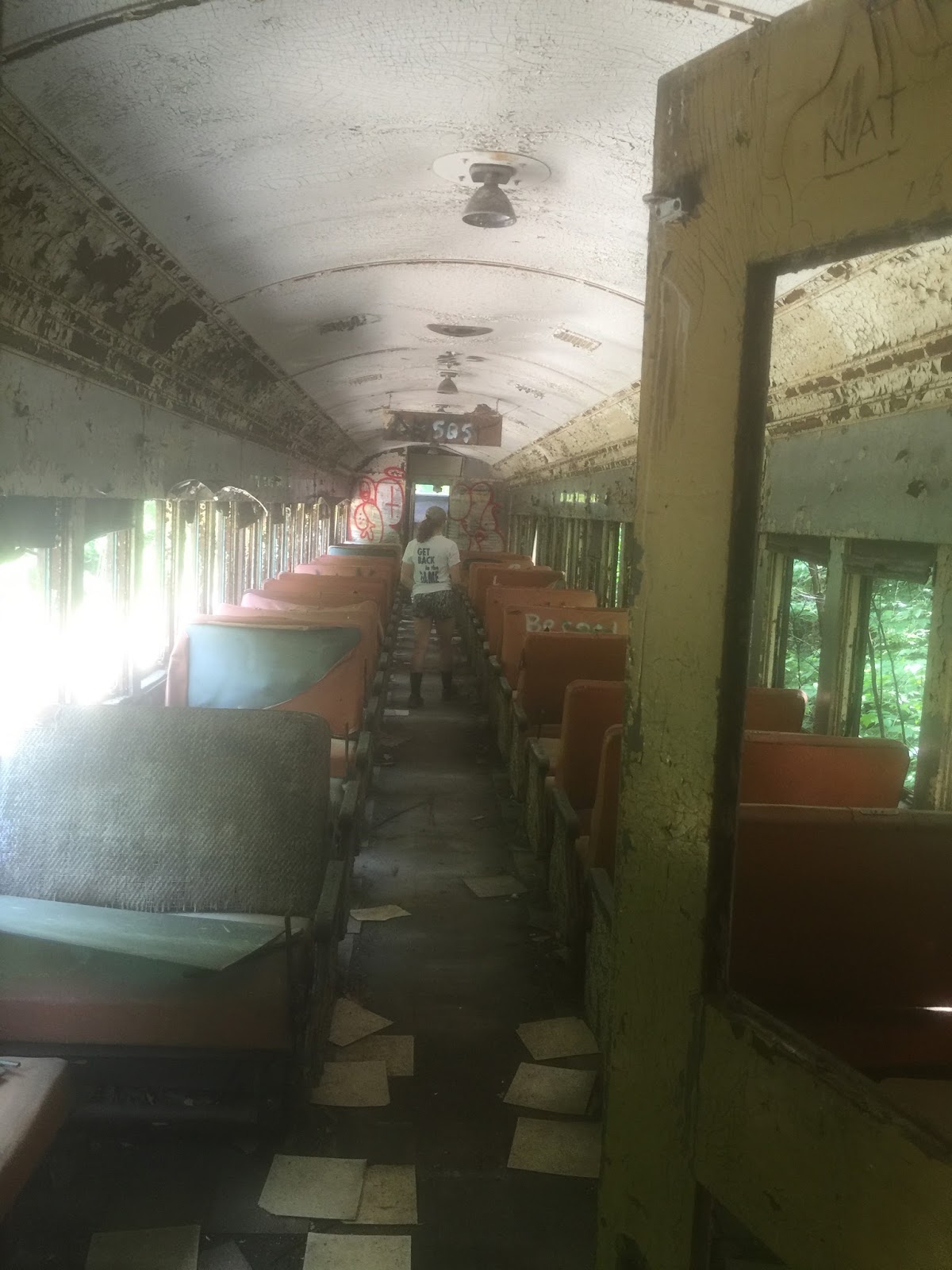
Besides that tidbit of information I don't know any other history of the train, so instead I'll share some pictures. We climbed aboard a passenger car which in its day must have been state of the art, but was now just a shell of its former glory.


This was Madison walking the aisle of another passenger car as if trying to remember where her seat is. She told me to make her look "wistful" in this picture.

And here's a shot of the overhead compartments. Never mind a suitcase, you'd be lucky to fit just your toiletries into one of them.


With a bit of muscle some of the benches still actually worked. They could either all be facing forward, or you could pull a lever and flip the back so that every other bench was facing each other.

Logan found a seat at the front of the train that looked like it came with some importance, so of course he claimed that as "his spot".


To answer a couple of questions about this trip, yes the tracks we were walking down are active tracks in the summertime, and no we probably should not have been in this area. But we were careful of our surroundings, respectful of the property, took nothing but pictures and left nothing but footprints.

Which made this one of the more memorable ways I've ever spent a beautiful summer's day with the family.

Friday, January 6, 2017

Our Alice


Make a particular half-mile hike into the woods of Barrington and you will find this old cellar foundation, one of hundreds that exist throughout the woods of New Hampshire.


But while at first glance this might seem like just another place where a house used to stand, one thing differentiates it from any other foundation I've come across. This one has a gravestone in the middle of it.

The stone belongs to Alice L. who died in 1863 at 11 months and 10 days of age, details which are listed on one side of the gravestone. On the other side is the simple yet loving phrase; Our Alice.

What does it mean that this gravestone stands alone within these walls? My first thought was the obvious one. Most people in the 1800's didn't have much money, which I assumed was the case here, and so I guessed the family buried their infant girl in the basement of their house because they couldn't afford a plot. Then over time the house was destroyed and only the things that were made of stone - the house foundation and the headstone - remained.

That is one possibility, but then the question becomes how could they have afforded the headstone if they had no money?

A second possibility is that the gravestone was maliciously placed in this spot. If you walk about 300 feet deeper into the woods you will find a family graveyard with roughly a dozen gravestones, ranging from small chunks of rock to full-size slabs. Many are toppled or in various states of decay, and the popular theory is that Alice's gravestone was moved from this nearby graveyard to the middle of the foundation. But since the graveyard was cataloged in its current condition 40 years ago, it had to have happened sometime prior to that.


I hate the idea of anyone's gravestone being vandalized, but if that's what happened I'm at least happy that Alice's headstone - perhaps due to its location and the extra attention it's been given - has endured in better condition than many of those remaining in the family's forgotten graveyard.
Our Alice can be found along Tibbets Trail in the Atlantic White Cedar Swamp 

Friday, December 23, 2016

Skull Cliff


Take the knowledge that you will someday be these bones, and enjoy now all that is precious. ICHABOD. YME... 2001

Ichabod's creepy yet inspirational message once adorned this colorful cliff on an abandoned quarry in Saugus Massachusetts. Although time and vandals have obscured the writing to the point of being illegible, the hundreds of skeletons that were painted alongside it have somewhat held up over time.

Skull Cliff sits on the outskirts of the Lynn Woods Reservation, a 2,200 acre playground that includes other head-scratching places such as the Dungeon Rock Cave. But while the history of that spot is well documented, the most that seems to been known about Skull Cliff is just what was painted in the message, that the artist calls himself Ichabod and painted this 35 foot tall cliff in 2001. And if the article in this link is referring to the same guy - which judging by the use of skulls in his other work I believe it is - Ichabod is arguably the most recognized freight train graffiti artist in America. http://www.theworldsbestever.com/2015/09/22/parallel-rails-ichabod/.

Driving to this place is no easy trick, to the point where we almost gave up looking for it. Our directions said to follow a public trail off Route 1, but what they didn't say was that the trail began in the back of a Jeep dealership's parking lot. By our third time driving by we finally figured it out, so trying not to make eye contact with any salespeople we drove through the dealership and sure enough found a parking area at the rear with a trail leading off. There were even chairs and a picnic table set up to reassure us it was okay to be there.

Once you figure out the driving part, getting to Skull Cliff is actually an easy and enjoyable half-mile hike. Exploring the cliff requires caution, however. Nothing so terrible that Tina couldn't climb it, just some tricky rocks and broken glass to be watchful of while making your way down. My advice is to brave your way to the bottom of the cliff though, as that's where the best view is.

My favorite places to visit are those created through a labor of love. I wondered how many days or even weeks Ichabod spent painting this cliff, how many gallons of paint he lugged through the woods, and how many trips did he make up and down his ladder. Grueling work for something he wouldn't make a dime doing and in fact would have cost him money. I tried to imagine the mind of this talented person, but I live in such a different world I'm not sure it's possible. Through a couple infrequent interviews he's given he describes his lifestyle these past 15 years as one without roots, having very little money, rarely holding a job, painting freight cars on almost a daily basis, all while facing his daily struggles with asperger syndrome. By his account he's illegally spray painted over 3,000 train cars in that time, and although he's shunned the social media notoriety that others in his circles seek, online fan groups have still crept up for Ichabod.

I regret not knowing about Skull Cliff in its prime. There are some fascinating pictures when it was freshly painted that are beautiful. But even 15 years later it's an impressive sight through the trees and bushes, and worth taking the trip if you're ever driving along Route 1 and have a few hours to spare.


Friday, December 16, 2016

The Search For Newton's Elusive Stone Chamber


As I learned during my recent visit to Danville's Beehive Hut, New England is littered with curious, man-made stone chambers that date back to the colonial days, and some think even further.
Danville's "Beehive Hut" Stone Chamber

This is the story of my search for an unmarked chamber said to exist in the woods of Newton, New Hampshire. Not that I plan on writing about each and every one of these I hunt down, but this one took me four attempts plus some begging to locate, therefore Newton is getting its own entry.

Our first attempt to find it was thwarted by the combined forces of Mother Nature and young children. A pounding rain had let loose on our drive to the site, but I've gotten soaked on explorations before so we decided to keep going. That's when Tina's phone rang. Our kids were home and power had just gone out. This was a bit tougher, especially since dusk was coming and they'd be alone in the dark, but the trail was just minutes away so we told them to go count the glow-in-the-dark stars on our ceiling and we be home soon. Then we rounded a corner and that's where this day's attempt came to and end. A firetruck was parked right where the trail began and its flashing lights told us we weren't going any further. The storm had taken down a large tree and police had the whole road closed.

My second attempt came the following weekend with Tina and Logan. Tricked by how easy to find Danville's stone chamber was, I planned on this entire adventure being just a quick stop and go. But things were anything but easy, starting with the fact that the trail was city-owned and marked no trespassing. That ruled out Logan and Tina going in, but I doubted anyone would get too excited over a 50-year old man searching for a cave - especially if I abided by the motto take nothing but pictures, leave nothing but footprints. So into the woods I went. And a half hour later, out I came - empty handed and sweaty. I'd left plenty of footprints but didn't get any pictures.

Back to the drawing board I went, but after triple-checking my research I was sure I had the right spot. Maybe not precisely, but I was definitely within a few hundred feet in one direction or another. So the next weekend I planned attempt number three, which was going to be an all out sweep of the area. I would bring my mountain bike and search every trail in those woods, and where there weren't any trails I would make them.

I succeeded in half my mission that weekend, I created a whole lot of trails where there weren't any. The map below, which could easily be mistaken for the wanderings of my daughter through the Fox Run Mall, is actually a GPS recording of my 6+ miles of searching.

Although I still didn't find the chamber, there were enough cool things in the woods to at least make the afternoon interesting. First there was this piece of metal I ran over, which when I began digging almost had me convinced I'd found a buried car.

Then there were these cameras mounted on trees, which someone's going to get a good chuckle out of watching me staring dumbly into. I'm not sure what they're used for so I've just been telling people they belong to a group of Bigfoot hunters.

But without finding the chamber I had to call it quits, and I texted Tina to let her know I'd given it my best shot but was calling off the search. That night I made one last ditch attempt, however, and emailed a local author who has written extensively about stone structures throughout New England, including Newton's excavation in 1968. I asked if he could offer me any help, and for extra pity I sent him the map of my search. Maybe that did the trick because he wrote back and gave me the chamber's exact location. I'd been close - in fact at one point I had walked completely around the hill that was hiding it.

Which led me to the my fourth and final trip into these woods, and with my updated map it wasn't long before I found myself looking triumphantly at the chamber. Just like that my search was over and I'd be able to sleep at night again.

Like most of the stone chambers in New England this is a simple structure, and half the enjoyment comes from a day in the woods spent searching for them. And although this adventure came with a very large assist, I still considered it a success and had a satisfying moment sitting inside the Newton stone chamber.


Friday, December 9, 2016

Fire Watch Duty on Warner Hill


Our family has hiked to a handful of firetowers in New Hampshire over the years, but this summer was the first time we actually got to go inside a working one.

We'd been driving through the southern part of the state, and with a few hours to kill decided to swing by the Derry tower. It sits on the 605' peak of Warner Hill, which as far as firetowers in NH go is the lowest one we have. For comparison, the tower on Magalloway Mountain sits at 3,360'. But what Warner Hill Tower lacks in location it somewhat makes up for in size by being one of the tallest in NH. That nugget of info came to us directly from a retired firefighter named Wally. More on him in a moment, but first it's confession time. We didn't actually hike the meager 605' of Warner Hill "Mountain", we were lazy and drove up the access road instead. But in our defense Logan and I had completed a 9 mile mountain bike ride earlier that day, and ol' jelly legs just wasn't up for any more exercise. I'll let you decide which one of us that was.

Although you're free to climb their stairs, firetowers are tall, narrow, rickety things that not everyone is willing to dart right up.

Derry tower is no exception to this, and Tina is just one of those hesitant people. So while she remained on the ground doing her best impression of the Little Engine That Could, Logan and I started up. We reached the top platform and immediately noticed something was different. The trap door opening to the cabin, which every other time we had climbed a tower was shut and locked, was swung wide open. Someone was up there.

Not wanting to disturb whoever was inside, we spent a few minutes looking around and pretending we knew which mountains we could see in the distance, when I heard a voice from above.

"You coming up?"

An invitation to actually go inside a firetower? You bet we were. Next thing I knew Logan and I were standing inside the cabin looking out.

The fellow who had beckoned us up introduced himself as Wally, and here's the first of several things I learned that day - New Hampshire's firetowers are still active. Somehow I'd never considered that they were. But I'd never considered that they weren't, either - I simply thought they were fun to climb. They're still in use though. Not every day, but whenever the fire danger is at level 3 or higher the towers are manned. And Wally could speak with authority on this because he'd been manning this particular tower for 31 years.

I asked him the last time he'd spotted something worth reporting and he said it was about a week ago in Candia, which turned into a 3-day fire after making its way underground into the roots. He then spent some time showing us his tools of the trade, which consisted of radio equipment, binoculars, and this map which he used to help us locate distant sites such as Boston to the south and Mount Agamenticus - or Mount "Aggy" - to the north.

We talked a bit longer and learned the history of the Derry tower. It was an ex-military lookout that was used in WWII to watch for planes coming in over the Atlantic. Had any been spotted, the tower would have radio'd over to Manchester Airport for support. After the war the lookout was converted to a fire watch tower, and without a need to see over the ocean the trees in that direction had been allowed to grow rampant and obstruct the view of the water.

It was about this time that the combination of affirmations and Dramamine must have worked their magic, because Tina braved the tower and joined us in the cabin. We were just wrapping up, but Wally was happy to give her the tour all over again and allow us more pictures. He ended by telling Tina that his wife was the reason he still came up here to do this job, so that he could have his alone time. Then he gave us the kind of wink that said he may or may not be kidding.

There are sixteen firetowers still standing in New Hampshire, and fifteen of them remain on public land and open to climb. Next time you're in the mood for a hike, consider a mountain with one of them at its peak - chances are if you live in New Hampshire there's one within an hour drive from you. And if you're lucky, you may even find a host as gracious as we did.

Links:
New Hampshire Fire Tower List

Friday, December 2, 2016

Hiking Abandoned Route 95


On an unseasonably warm day this past October Barry and I walked down the center of Interstate 95 in Massachusetts without any regard for traffic. That's because there wasn't any. What was in abundance however were rusted guardrails, faded paint lines, and waves of vegetation that had swallowed the breakdown lane and was continuing inward. Forty years of abandonment would do that to a highway.

For those who have driven on I-95 in Massachusetts, this is not some post-apocalyptic, parallel universe I'm describing. It was indeed I-95.  At least, it's a portion of what used to be I-95. In 1976 this section of road was abandoned and rerouted between Danvers and Newburyport in a widening project, leaving this discarded piece of interstate to the bicyclists and hikers such as ourselves.

Abandoned I-95 is not a place you're apt to stumble upon accidentally as the road itself isn't visible from any part of our modern I-95. But knowing where it began (thank you Google Earth) we found a parking spot alongside some construction equipment and made a quick walk down a trail to start our journey.

In the battle between nature and mans creations, there is no battle - the only question is how long it will take nature to reclaim her territory. We witnessed both the early stages of this takeover, such as these small trees sprouting through the tar,

And the later stages of this takeover, such as this beast lifting apart the road.

Remnants other than just blacktop were plentiful too. I'd forgotten about old fashioned wire guardrails such as these

Not all of the remnants were above ground, either. Here is one of several drainage tunnels which I couldn't resist crawling into.

Maybe a mile into our journey the pavement abruptly ended where it met a hill, but our fun didn't end there. Woods surrounded the highway on both sides, and so we took to the trees for our return trip. As a reward for our curiosity we were greeted with a variety of cool things, such as a rusted old engine,

And this rickety platform that, try as I might, I couldn't get Barry to climb onto.

The surprise of the day was that, unlike so many other hidden places we visit, there was very little graffiti here. It wasn't completely bare of it, and we did see a few rude pictures that I'd have hidden from my daughter's eyes, but for a mile of abandoned blacktop it was relatively untouched.

And of the graffiti abandoned I-95 does have, there are actually more inspirational messages than rude ones.